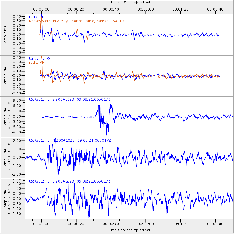
KSU1 Kansas State University--Konza Prairie, Kansas, USA - Earthquake Result Viewer
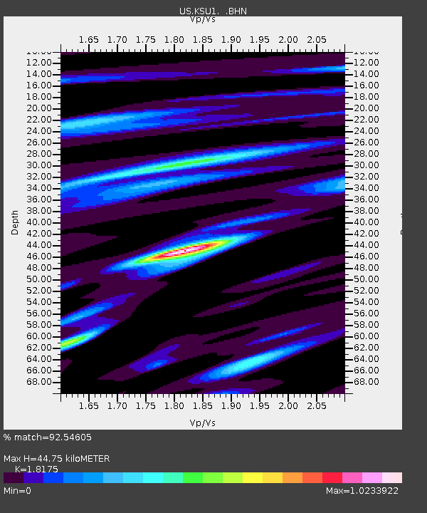
Earthquake location: Near West Coast Of Honshu, Japan
Earthquake latitude/longitude: 37.2/138.8
Earthquake time(UTC): 2004/10/23 (297) 08:56:00 GMT
Earthquake Depth: 16 km
Earthquake Magnitude: 6.4 MB, 6.3 MS, 6.6 MW, 6.4 MW
Earthquake Catalog/Contributor: WHDF/NEIC
Network: US United States National Seismic Network
Station: KSU1 Kansas State University--Konza Prairie, Kansas, USA
Lat/Lon: 39.10 N/96.61 W
Elevation: 347 m
Distance: 88.5 deg
Az: 39.837 deg
Baz: 318.917 deg
Ray Param: 0.042505413
Estimated Moho Depth: 44.75 km
Estimated Crust Vp/Vs: 1.82
Assumed Crust Vp: 6.483 km/s
Estimated Crust Vs: 3.567 km/s
Estimated Crust Poisson's Ratio: 0.28
Radial Match: 92.54605 %
Radial Bump: 400
Transverse Match: 82.52916 %
Transverse Bump: 400
SOD ConfigId: 110177
Insert Time: 2010-03-05 06:56:09.104 +0000
GWidth: 2.5
Max Bumps: 400
Tol: 0.001

Signal To Noise

ChannelStoNSTALTA
US:KSU1: :BHN:20041023T09:08:21.065017Z3.06365135.4375965E-71.7748744E-7
US:KSU1: :BHE:20041023T09:08:21.065017Z2.28401114.5679997E-71.9999902E-7
US:KSU1: :BHZ:20041023T09:08:21.065017Z17.116873.122189E-61.8240418E-7
Arrivals
Ps5.8 SECOND
PpPs19 SECOND
PsPs/PpSs25 SECOND