You are here: Home > Network List > US - United States National Seismic Network Stations List
> Station KSU1 Kansas State University--Konza Prairie, Kansas, USA > Earthquake Result Viewer
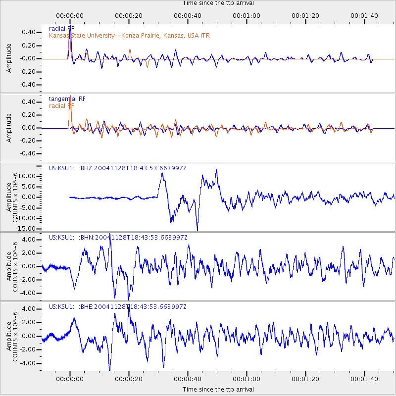
KSU1 Kansas State University--Konza Prairie, Kansas, USA - Earthquake Result Viewer

| Earthquake location: |
Hokkaido, Japan Region |
| Earthquake latitude/longitude: |
43.0/145.1 |
| Earthquake time(UTC): |
2004/11/28 (333) 18:32:14 GMT |
| Earthquake Depth: |
39 km |
| Earthquake Magnitude: |
6.4 MB, 6.7 MS, 7.0 MW, 7.0 MW |
| Earthquake Catalog/Contributor: |
WHDF/NEIC |
|
| Network: |
US United States National Seismic Network |
| Station: |
KSU1 Kansas State University--Konza Prairie, Kansas, USA |
| Lat/Lon: |
39.10 N/96.61 W |
| Elevation: |
347 m |
|
| Distance: |
81.0 deg |
| Az: |
43.935 deg |
| Baz: |
319.147 deg |
| Ray Param: |
0.04783839 |
| Estimated Moho Depth: |
44.0 km |
| Estimated Crust Vp/Vs: |
1.81 |
| Assumed Crust Vp: |
6.483 km/s |
| Estimated Crust Vs: |
3.577 km/s |
| Estimated Crust Poisson's Ratio: |
0.28 |
|
| Radial Match: |
95.09996 % |
| Radial Bump: |
400 |
| Transverse Match: |
86.478485 % |
| Transverse Bump: |
400 |
| SOD ConfigId: |
110177 |
| Insert Time: |
2010-03-05 06:56:12.014 +0000 |
| GWidth: |
2.5 |
| Max Bumps: |
400 |
| Tol: |
0.001 |
|
Signal To Noise
| Channel | StoN | STA | LTA |
| US:KSU1: :BHN:20041128T18:43:53.663997Z | 5.160268 | 1.680637E-6 | 3.2568792E-7 |
| US:KSU1: :BHE:20041128T18:43:53.663997Z | 5.270309 | 1.5821431E-6 | 3.001993E-7 |
| US:KSU1: :BHZ:20041128T18:43:53.663997Z | 23.342258 | 7.0279734E-6 | 3.010837E-7 |
| Arrivals |
| Ps | 5.7 SECOND |
| PpPs | 19 SECOND |
| PsPs/PpSs | 24 SECOND |


