You are here: Home > Network List > TA - USArray Transportable Network (new EarthScope stations) Stations List
> Station F26K Sheenjek River, AK, USA > Earthquake Result Viewer
F26K Sheenjek River, AK, USA - Earthquake Result Viewer
*The percent match for this event was below the threshold and hence no stack was calculated.
| Earthquake location: |
South Korea |
| Earthquake latitude/longitude: |
35.8/129.2 |
| Earthquake time(UTC): |
2016/09/12 (256) 11:32:55 GMT |
| Earthquake Depth: |
13 km |
| Earthquake Magnitude: |
5.4 Mww |
| Earthquake Catalog/Contributor: |
NEIC PDE/us |
|
| Network: |
TA USArray Transportable Network (new EarthScope stations) |
| Station: |
F26K Sheenjek River, AK, USA |
| Lat/Lon: |
67.69 N/144.15 W |
| Elevation: |
683 m |
|
| Distance: |
56.2 deg |
| Az: |
27.294 deg |
| Baz: |
282.378 deg |
| Ray Param: |
$rayparam |
*The percent match for this event was below the threshold and hence was not used in the summary stack. |
|
| Radial Match: |
62.030598 % |
| Radial Bump: |
368 |
| Transverse Match: |
57.93304 % |
| Transverse Bump: |
400 |
| SOD ConfigId: |
11737051 |
| Insert Time: |
2019-04-25 12:29:54.589 +0000 |
| GWidth: |
2.5 |
| Max Bumps: |
400 |
| Tol: |
0.001 |
|
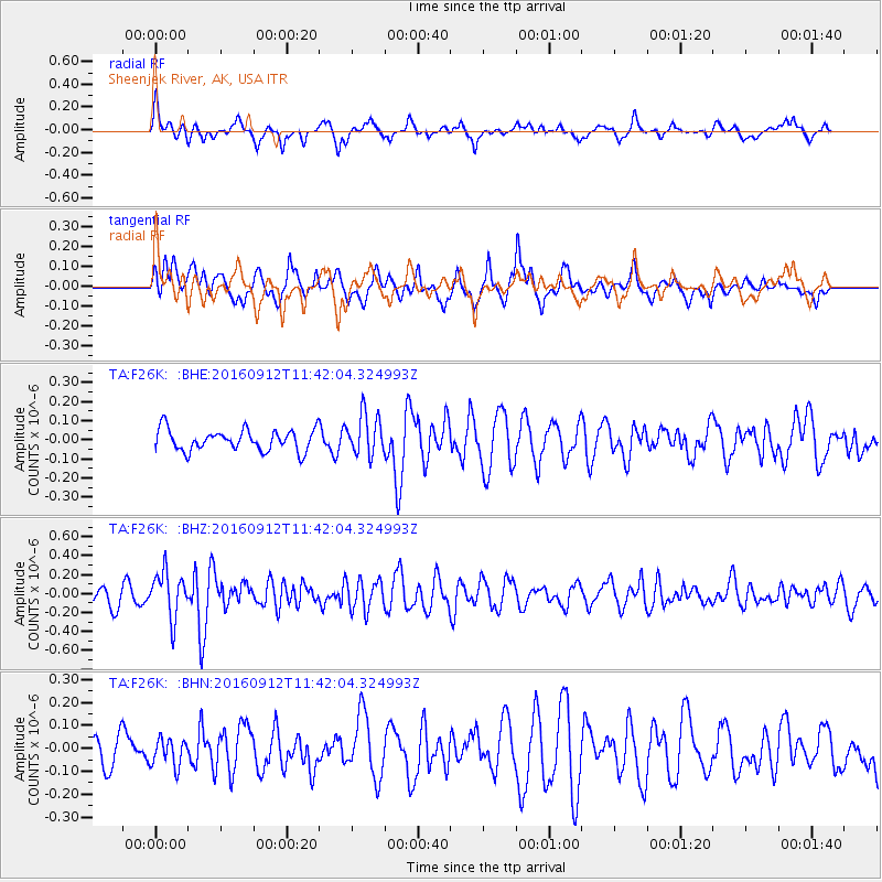
Signal To Noise
| Channel | StoN | STA | LTA |
| TA:F26K: :BHZ:20160912T11:42:04.324993Z | 2.5097911 | 2.397459E-7 | 9.552425E-8 |
| TA:F26K: :BHN:20160912T11:42:04.324993Z | 0.8258079 | 5.887135E-8 | 7.12894E-8 |
| TA:F26K: :BHE:20160912T11:42:04.324993Z | 1.9502302 | 1.07769836E-7 | 5.526006E-8 |
| Arrivals |
| Ps | |
| PpPs | |
| PsPs/PpSs | |


