You are here: Home > Network List > WY - Yellowstone Wyoming Seismic Network Stations List
> Station YHH Holmes Hill, YNP, WY, USA > Earthquake Result Viewer
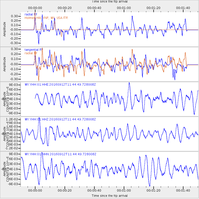
YHH Holmes Hill, YNP, WY, USA - Earthquake Result Viewer
*The percent match for this event was below the threshold and hence no stack was calculated.
| Earthquake location: |
South Korea |
| Earthquake latitude/longitude: |
35.8/129.2 |
| Earthquake time(UTC): |
2016/09/12 (256) 11:32:55 GMT |
| Earthquake Depth: |
13 km |
| Earthquake Magnitude: |
5.4 Mww |
| Earthquake Catalog/Contributor: |
NEIC PDE/us |
|
| Network: |
WY Yellowstone Wyoming Seismic Network |
| Station: |
YHH Holmes Hill, YNP, WY, USA |
| Lat/Lon: |
44.79 N/110.85 W |
| Elevation: |
2717 m |
|
| Distance: |
83.1 deg |
| Az: |
38.431 deg |
| Baz: |
314.784 deg |
| Ray Param: |
$rayparam |
*The percent match for this event was below the threshold and hence was not used in the summary stack. |
|
| Radial Match: |
64.16881 % |
| Radial Bump: |
400 |
| Transverse Match: |
63.628338 % |
| Transverse Bump: |
400 |
| SOD ConfigId: |
11737051 |
| Insert Time: |
2019-04-25 12:31:16.324 +0000 |
| GWidth: |
2.5 |
| Max Bumps: |
400 |
| Tol: |
0.001 |
|
Signal To Noise
| Channel | StoN | STA | LTA |
| WY:YHH:01:HHZ:20160912T11:44:49.728008Z | 2.1929483 | 5.963252E-9 | 2.7192852E-9 |
| WY:YHH:01:HHN:20160912T11:44:49.728008Z | 1.3012629 | 5.567972E-9 | 4.2788986E-9 |
| WY:YHH:01:HHE:20160912T11:44:49.728008Z | 1.2924289 | 3.1315275E-9 | 2.4229787E-9 |
| Arrivals |
| Ps | |
| PpPs | |
| PsPs/PpSs | |


