You are here: Home > Network List > AG - Arkansas Seismic Network Stations List
> Station U40A Yellville, AR > Earthquake Result Viewer
U40A Yellville, AR - Earthquake Result Viewer
| Earthquake location: |
Northern Colombia |
| Earthquake latitude/longitude: |
7.3/-76.1 |
| Earthquake time(UTC): |
2016/09/14 (258) 01:58:30 GMT |
| Earthquake Depth: |
10 km |
| Earthquake Magnitude: |
5.9 MWP |
| Earthquake Catalog/Contributor: |
NEIC PDE/NEIC COMCAT |
|
| Network: |
AG Arkansas Seismic Network |
| Station: |
U40A Yellville, AR |
| Lat/Lon: |
36.36 N/92.85 W |
| Elevation: |
374 m |
|
| Distance: |
32.7 deg |
| Az: |
334.486 deg |
| Baz: |
148.042 deg |
| Ray Param: |
0.078541055 |
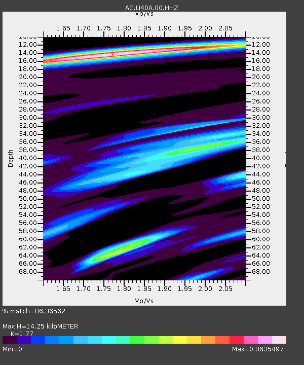
| Estimated Moho Depth: |
14.25 km |
| Estimated Crust Vp/Vs: |
1.77 |
| Assumed Crust Vp: |
6.53 km/s |
| Estimated Crust Vs: |
3.69 km/s |
| Estimated Crust Poisson's Ratio: |
0.27 |
|
| Radial Match: |
86.36562 % |
| Radial Bump: |
232 |
| Transverse Match: |
66.565346 % |
| Transverse Bump: |
321 |
| SOD ConfigId: |
11737051 |
| Insert Time: |
2019-04-25 12:33:21.801 +0000 |
| GWidth: |
2.5 |
| Max Bumps: |
400 |
| Tol: |
0.001 |
|
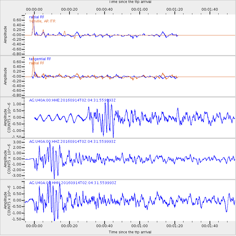
Signal To Noise
| Channel | StoN | STA | LTA |
| AG:U40A:00:HHZ:20160914T02:04:31.559993Z | 5.480134 | 9.457358E-7 | 1.725753E-7 |
| AG:U40A:00:HHN:20160914T02:04:31.559993Z | 3.307777 | 4.943448E-7 | 1.4944925E-7 |
| AG:U40A:00:HHE:20160914T02:04:31.559993Z | 2.5773263 | 4.331376E-7 | 1.6805694E-7 |
| Arrivals |
| Ps | 1.8 SECOND |
| PpPs | 5.6 SECOND |
| PsPs/PpSs | 7.4 SECOND |


