You are here: Home > Network List > CN - Canadian National Seismograph Network Stations List
> Station INK INUVIK, NT > Earthquake Result Viewer
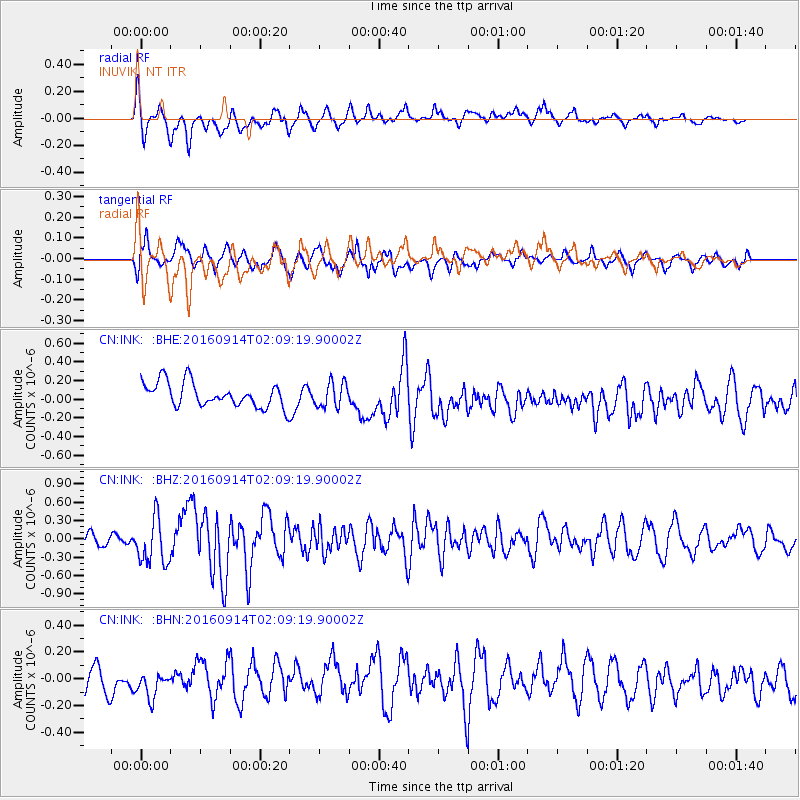
INK INUVIK, NT - Earthquake Result Viewer
*The percent match for this event was below the threshold and hence no stack was calculated.
| Earthquake location: |
Northern Colombia |
| Earthquake latitude/longitude: |
7.3/-76.1 |
| Earthquake time(UTC): |
2016/09/14 (258) 01:58:30 GMT |
| Earthquake Depth: |
10 km |
| Earthquake Magnitude: |
5.9 MWP |
| Earthquake Catalog/Contributor: |
NEIC PDE/NEIC COMCAT |
|
| Network: |
CN Canadian National Seismograph Network |
| Station: |
INK INUVIK, NT |
| Lat/Lon: |
68.31 N/133.53 W |
| Elevation: |
44 m |
|
| Distance: |
71.6 deg |
| Az: |
340.716 deg |
| Baz: |
118.225 deg |
| Ray Param: |
$rayparam |
*The percent match for this event was below the threshold and hence was not used in the summary stack. |
|
| Radial Match: |
67.940605 % |
| Radial Bump: |
400 |
| Transverse Match: |
59.003387 % |
| Transverse Bump: |
400 |
| SOD ConfigId: |
11737051 |
| Insert Time: |
2019-04-25 12:36:31.153 +0000 |
| GWidth: |
2.5 |
| Max Bumps: |
400 |
| Tol: |
0.001 |
|
Signal To Noise
| Channel | StoN | STA | LTA |
| CN:INK: :BHZ:20160914T02:09:19.90002Z | 2.7068267 | 3.8230397E-7 | 1.4123695E-7 |
| CN:INK: :BHN:20160914T02:09:19.90002Z | 0.9288778 | 9.117813E-8 | 9.815945E-8 |
| CN:INK: :BHE:20160914T02:09:19.90002Z | 1.0036856 | 1.3294664E-7 | 1.3245845E-7 |
| Arrivals |
| Ps | |
| PpPs | |
| PsPs/PpSs | |


