You are here: Home > Network List > US - United States National Seismic Network Stations List
> Station GOGA Godfrey, Georgia, USA > Earthquake Result Viewer
GOGA Godfrey, Georgia, USA - Earthquake Result Viewer
| Earthquake location: |
Iceland |
| Earthquake latitude/longitude: |
64.0/-20.8 |
| Earthquake time(UTC): |
2000/06/21 (173) 00:51:46 GMT |
| Earthquake Depth: |
10 km |
| Earthquake Magnitude: |
6.1 MB, 6.6 MS, 6.5 MW, 6.4 MW |
| Earthquake Catalog/Contributor: |
WHDF/NEIC |
|
| Network: |
US United States National Seismic Network |
| Station: |
GOGA Godfrey, Georgia, USA |
| Lat/Lon: |
33.41 N/83.47 W |
| Elevation: |
150 m |
|
| Distance: |
48.6 deg |
| Az: |
262.152 deg |
| Baz: |
31.492 deg |
| Ray Param: |
0.069239736 |
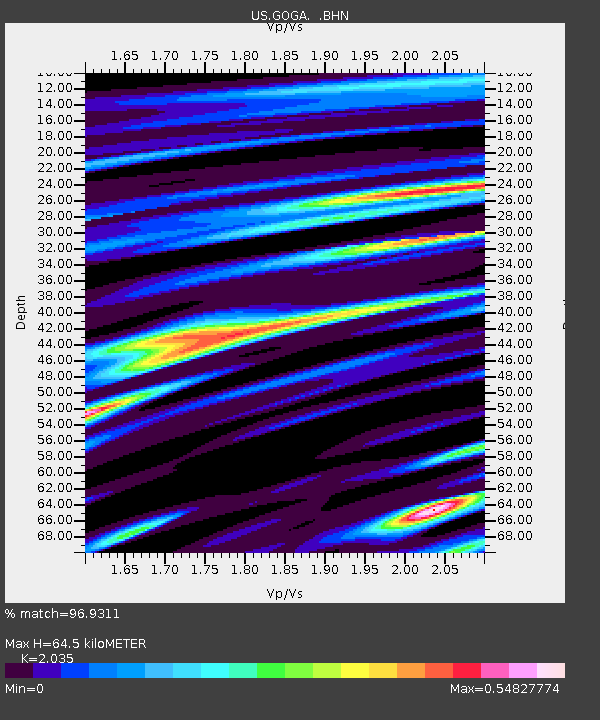
| Estimated Moho Depth: |
64.5 km |
| Estimated Crust Vp/Vs: |
2.04 |
| Assumed Crust Vp: |
6.565 km/s |
| Estimated Crust Vs: |
3.226 km/s |
| Estimated Crust Poisson's Ratio: |
0.34 |
|
| Radial Match: |
96.9311 % |
| Radial Bump: |
287 |
| Transverse Match: |
86.34833 % |
| Transverse Bump: |
400 |
| SOD ConfigId: |
110165 |
| Insert Time: |
2010-03-05 06:57:56.659 +0000 |
| GWidth: |
2.5 |
| Max Bumps: |
400 |
| Tol: |
0.001 |
|
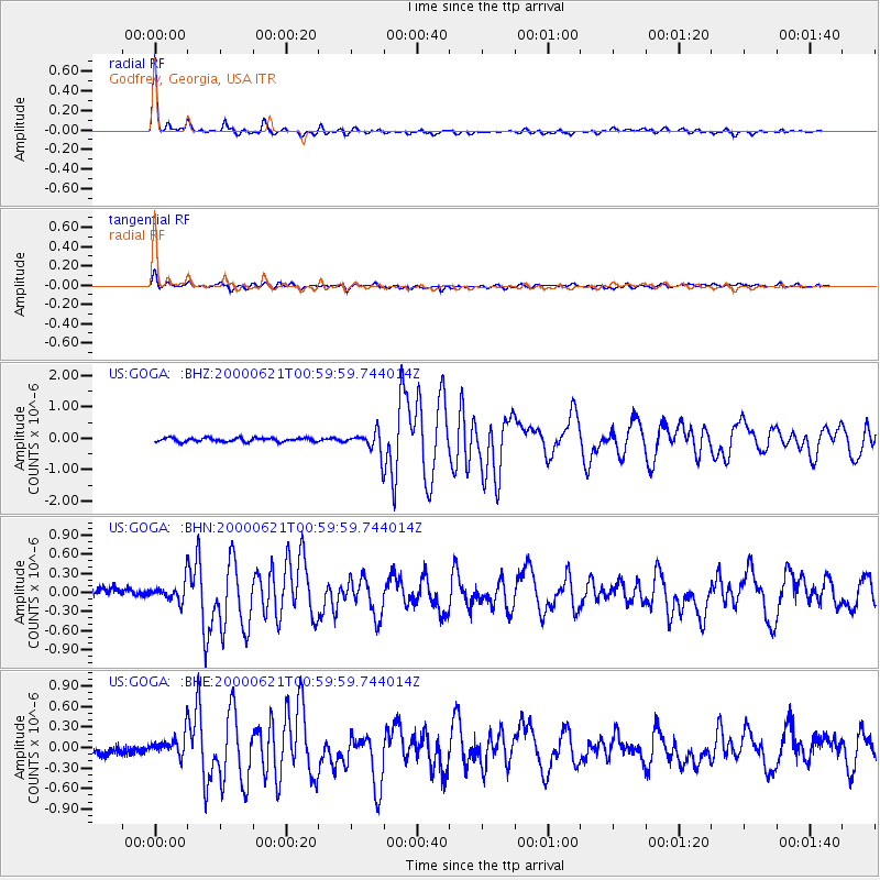
Signal To Noise
| Channel | StoN | STA | LTA |
| US:GOGA: :BHN:20000621T00:59:59.744014Z | 2.0765579 | 1.4766788E-7 | 7.111185E-8 |
| US:GOGA: :BHE:20000621T00:59:59.744014Z | 2.7907226 | 1.6354652E-7 | 5.8603643E-8 |
| US:GOGA: :BHZ:20000621T00:59:59.744014Z | 5.896946 | 3.4858797E-7 | 5.9113304E-8 |
| Arrivals |
| Ps | 11 SECOND |
| PpPs | 28 SECOND |
| PsPs/PpSs | 39 SECOND |


