You are here: Home > Network List > NN - Western Great Basin/Eastern Sierra Nevada Stations List
> Station OMMB Old Mammoth Mine, surface, wgs-84 > Earthquake Result Viewer
OMMB Old Mammoth Mine, surface, wgs-84 - Earthquake Result Viewer
| Earthquake location: |
Northern Colombia |
| Earthquake latitude/longitude: |
7.3/-76.1 |
| Earthquake time(UTC): |
2016/09/14 (258) 01:58:30 GMT |
| Earthquake Depth: |
10 km |
| Earthquake Magnitude: |
5.9 MWP |
| Earthquake Catalog/Contributor: |
NEIC PDE/NEIC COMCAT |
|
| Network: |
NN Western Great Basin/Eastern Sierra Nevada |
| Station: |
OMMB Old Mammoth Mine, surface, wgs-84 |
| Lat/Lon: |
37.61 N/119.00 W |
| Elevation: |
2768 m |
|
| Distance: |
49.2 deg |
| Az: |
314.388 deg |
| Baz: |
116.794 deg |
| Ray Param: |
0.06888391 |
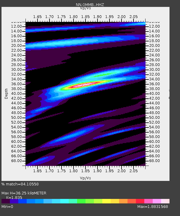
| Estimated Moho Depth: |
36.25 km |
| Estimated Crust Vp/Vs: |
1.84 |
| Assumed Crust Vp: |
6.291 km/s |
| Estimated Crust Vs: |
3.428 km/s |
| Estimated Crust Poisson's Ratio: |
0.29 |
|
| Radial Match: |
84.10558 % |
| Radial Bump: |
400 |
| Transverse Match: |
74.6573 % |
| Transverse Bump: |
400 |
| SOD ConfigId: |
11737051 |
| Insert Time: |
2019-04-25 12:39:31.695 +0000 |
| GWidth: |
2.5 |
| Max Bumps: |
400 |
| Tol: |
0.001 |
|

Signal To Noise
| Channel | StoN | STA | LTA |
| NN:OMMB: :HHZ:20160914T02:06:46.705012Z | 2.421023 | 2.7633612E-7 | 1.1414024E-7 |
| NN:OMMB: :HHN:20160914T02:06:46.705012Z | 3.1835454 | 1.582991E-7 | 4.9724154E-8 |
| NN:OMMB: :HHE:20160914T02:06:46.705012Z | 1.4299206 | 1.11010095E-7 | 7.763375E-8 |
| Arrivals |
| Ps | 5.1 SECOND |
| PpPs | 15 SECOND |
| PsPs/PpSs | 21 SECOND |


