You are here: Home > Network List > CI - Caltech Regional Seismic Network Stations List
> Station PLM Palomar, California, USA > Earthquake Result Viewer
PLM Palomar, California, USA - Earthquake Result Viewer
| Earthquake location: |
Near Coast Of Peru |
| Earthquake latitude/longitude: |
-16.3/-73.6 |
| Earthquake time(UTC): |
2001/06/23 (174) 20:33:14 GMT |
| Earthquake Depth: |
33 km |
| Earthquake Magnitude: |
6.7 MB, 8.2 MS, 8.4 MW, 7.8 ME |
| Earthquake Catalog/Contributor: |
WHDF/NEIC |
|
| Network: |
CI Caltech Regional Seismic Network |
| Station: |
PLM Palomar, California, USA |
| Lat/Lon: |
33.35 N/116.86 W |
| Elevation: |
1660 m |
|
| Distance: |
64.3 deg |
| Az: |
320.502 deg |
| Baz: |
133.122 deg |
| Ray Param: |
0.058951013 |
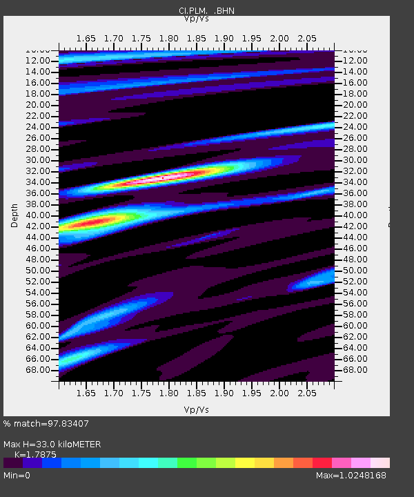
| Estimated Moho Depth: |
33.0 km |
| Estimated Crust Vp/Vs: |
1.79 |
| Assumed Crust Vp: |
6.264 km/s |
| Estimated Crust Vs: |
3.504 km/s |
| Estimated Crust Poisson's Ratio: |
0.27 |
|
| Radial Match: |
97.83407 % |
| Radial Bump: |
357 |
| Transverse Match: |
85.125656 % |
| Transverse Bump: |
400 |
| SOD ConfigId: |
4714 |
| Insert Time: |
2010-02-26 00:44:17.728 +0000 |
| GWidth: |
2.5 |
| Max Bumps: |
400 |
| Tol: |
0.001 |
|

Signal To Noise
| Channel | StoN | STA | LTA |
| CI:PLM: :BHN:20010623T20:43:15.562007Z | 1.49573 | 3.2498863E-7 | 2.1727759E-7 |
| CI:PLM: :BHE:20010623T20:43:15.562007Z | 1.3042178 | 2.17801E-7 | 1.6699741E-7 |
| CI:PLM: :BHZ:20010623T20:43:15.562007Z | 6.234498 | 8.766137E-7 | 1.4060694E-7 |
| Arrivals |
| Ps | 4.3 SECOND |
| PpPs | 14 SECOND |
| PsPs/PpSs | 18 SECOND |


