You are here: Home > Network List > US - United States National Seismic Network Stations List
> Station GOGA Godfrey, Georgia, USA > Earthquake Result Viewer
GOGA Godfrey, Georgia, USA - Earthquake Result Viewer
| Earthquake location: |
Central East Pacific Rise |
| Earthquake latitude/longitude: |
-4.1/-104.5 |
| Earthquake time(UTC): |
2001/06/26 (177) 12:33:52 GMT |
| Earthquake Depth: |
10 km |
| Earthquake Magnitude: |
5.0 MB, 5.8 MS, 6.0 MW, 6.0 MW |
| Earthquake Catalog/Contributor: |
WHDF/NEIC |
|
| Network: |
US United States National Seismic Network |
| Station: |
GOGA Godfrey, Georgia, USA |
| Lat/Lon: |
33.41 N/83.47 W |
| Elevation: |
150 m |
|
| Distance: |
42.2 deg |
| Az: |
26.482 deg |
| Baz: |
212.126 deg |
| Ray Param: |
0.073285945 |
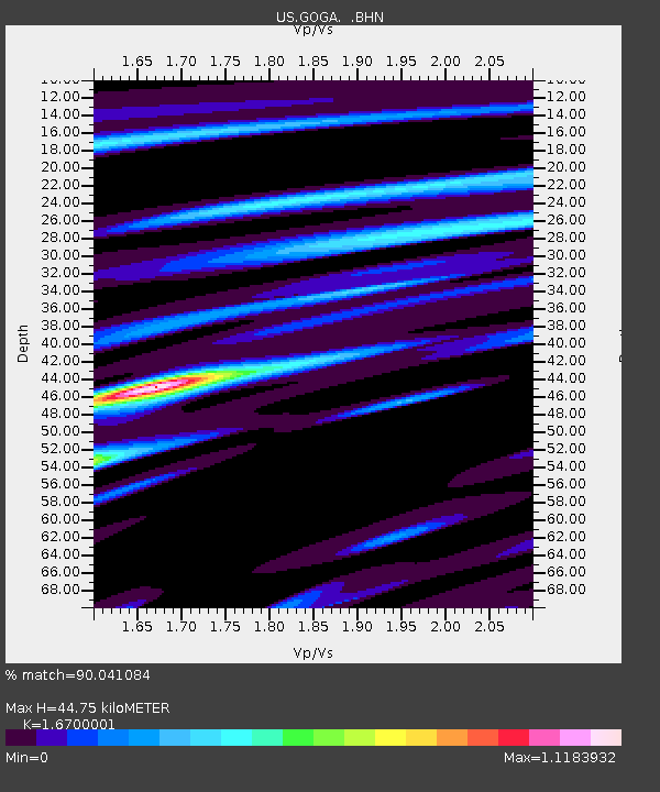
| Estimated Moho Depth: |
44.75 km |
| Estimated Crust Vp/Vs: |
1.67 |
| Assumed Crust Vp: |
6.565 km/s |
| Estimated Crust Vs: |
3.931 km/s |
| Estimated Crust Poisson's Ratio: |
0.22 |
|
| Radial Match: |
90.041084 % |
| Radial Bump: |
347 |
| Transverse Match: |
67.95136 % |
| Transverse Bump: |
400 |
| SOD ConfigId: |
110165 |
| Insert Time: |
2010-03-05 06:58:11.997 +0000 |
| GWidth: |
2.5 |
| Max Bumps: |
400 |
| Tol: |
0.001 |
|
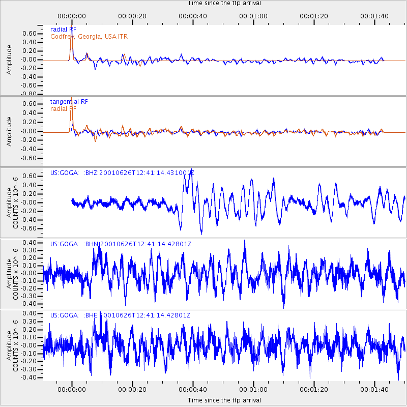
Signal To Noise
| Channel | StoN | STA | LTA |
| US:GOGA: :BHN:20010626T12:41:14.42801Z | 0.9692289 | 7.3178725E-8 | 7.5502E-8 |
| US:GOGA: :BHE:20010626T12:41:14.42801Z | 1.0592278 | 8.5219206E-8 | 8.0454086E-8 |
| US:GOGA: :BHZ:20010626T12:41:14.431001Z | 1.8167017 | 1.1714946E-7 | 6.44847E-8 |
| Arrivals |
| Ps | 4.9 SECOND |
| PpPs | 17 SECOND |
| PsPs/PpSs | 22 SECOND |


