You are here: Home > Network List > US - United States National Seismic Network Stations List
> Station GOGA Godfrey, Georgia, USA > Earthquake Result Viewer
GOGA Godfrey, Georgia, USA - Earthquake Result Viewer
| Earthquake location: |
Western Brazil |
| Earthquake latitude/longitude: |
-8.3/-71.7 |
| Earthquake time(UTC): |
2002/10/12 (285) 20:09:11 GMT |
| Earthquake Depth: |
534 km |
| Earthquake Magnitude: |
6.5 MB, 6.9 MW, 6.9 MW |
| Earthquake Catalog/Contributor: |
WHDF/NEIC |
|
| Network: |
US United States National Seismic Network |
| Station: |
GOGA Godfrey, Georgia, USA |
| Lat/Lon: |
33.41 N/83.47 W |
| Elevation: |
150 m |
|
| Distance: |
42.9 deg |
| Az: |
345.549 deg |
| Baz: |
162.826 deg |
| Ray Param: |
0.07024111 |
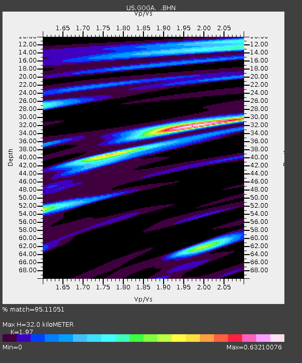
| Estimated Moho Depth: |
32.0 km |
| Estimated Crust Vp/Vs: |
1.97 |
| Assumed Crust Vp: |
6.565 km/s |
| Estimated Crust Vs: |
3.332 km/s |
| Estimated Crust Poisson's Ratio: |
0.33 |
|
| Radial Match: |
95.11051 % |
| Radial Bump: |
325 |
| Transverse Match: |
95.10288 % |
| Transverse Bump: |
288 |
| SOD ConfigId: |
110177 |
| Insert Time: |
2010-03-05 06:58:36.840 +0000 |
| GWidth: |
2.5 |
| Max Bumps: |
400 |
| Tol: |
0.001 |
|
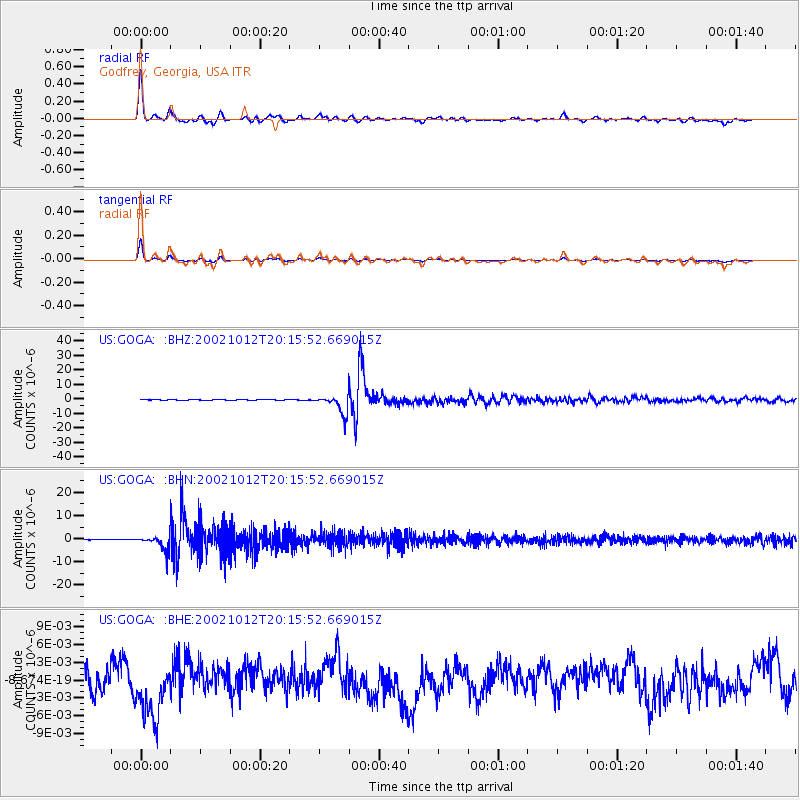
Signal To Noise
| Channel | StoN | STA | LTA |
| US:GOGA: :BHN:20021012T20:15:52.669015Z | 13.932662 | 3.2678558E-6 | 2.345464E-7 |
| US:GOGA: :BHE:20021012T20:15:52.669015Z | 1.7015727 | 4.6483173E-9 | 2.731777E-9 |
| US:GOGA: :BHZ:20021012T20:15:52.669015Z | 43.746372 | 6.639848E-6 | 1.5178054E-7 |
| Arrivals |
| Ps | 5.0 SECOND |
| PpPs | 14 SECOND |
| PsPs/PpSs | 19 SECOND |


