You are here: Home > Network List > CI - Caltech Regional Seismic Network Stations List
> Station PLM Palomar, California, USA > Earthquake Result Viewer
PLM Palomar, California, USA - Earthquake Result Viewer
| Earthquake location: |
Fiji Islands Region |
| Earthquake latitude/longitude: |
-21.7/-176.7 |
| Earthquake time(UTC): |
2001/07/04 (185) 07:06:31 GMT |
| Earthquake Depth: |
185 km |
| Earthquake Magnitude: |
5.9 MB, 5.8 MS, 6.5 MW, 6.5 MW |
| Earthquake Catalog/Contributor: |
WHDF/NEIC |
|
| Network: |
CI Caltech Regional Seismic Network |
| Station: |
PLM Palomar, California, USA |
| Lat/Lon: |
33.35 N/116.86 W |
| Elevation: |
1660 m |
|
| Distance: |
79.1 deg |
| Az: |
47.482 deg |
| Baz: |
234.967 deg |
| Ray Param: |
0.04875176 |
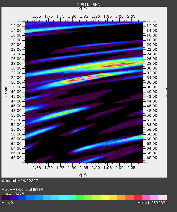
| Estimated Moho Depth: |
34.0 km |
| Estimated Crust Vp/Vs: |
1.85 |
| Assumed Crust Vp: |
6.264 km/s |
| Estimated Crust Vs: |
3.39 km/s |
| Estimated Crust Poisson's Ratio: |
0.29 |
|
| Radial Match: |
94.20397 % |
| Radial Bump: |
400 |
| Transverse Match: |
87.4339 % |
| Transverse Bump: |
400 |
| SOD ConfigId: |
4714 |
| Insert Time: |
2010-02-26 00:44:21.148 +0000 |
| GWidth: |
2.5 |
| Max Bumps: |
400 |
| Tol: |
0.001 |
|

Signal To Noise
| Channel | StoN | STA | LTA |
| CI:PLM: :BHN:20010704T07:17:44.261011Z | 2.5193799 | 2.3754987E-7 | 9.428903E-8 |
| CI:PLM: :BHE:20010704T07:17:44.261011Z | 2.269915 | 3.5655725E-7 | 1.5707955E-7 |
| CI:PLM: :BHZ:20010704T07:17:44.261011Z | 20.295153 | 1.0537943E-6 | 5.192345E-8 |
| Arrivals |
| Ps | 4.7 SECOND |
| PpPs | 15 SECOND |
| PsPs/PpSs | 20 SECOND |


