You are here: Home > Network List > TA - USArray Transportable Network (new EarthScope stations) Stations List
> Station MSTX Muleshoe, TX, USA > Earthquake Result Viewer
MSTX Muleshoe, TX, USA - Earthquake Result Viewer

| Earthquake location: |
Northern Colombia |
| Earthquake latitude/longitude: |
7.3/-76.1 |
| Earthquake time(UTC): |
2016/09/14 (258) 01:58:30 GMT |
| Earthquake Depth: |
10 km |
| Earthquake Magnitude: |
5.9 MWP |
| Earthquake Catalog/Contributor: |
NEIC PDE/NEIC COMCAT |
|
| Network: |
TA USArray Transportable Network (new EarthScope stations) |
| Station: |
MSTX Muleshoe, TX, USA |
| Lat/Lon: |
33.97 N/102.77 W |
| Elevation: |
1167 m |
|
| Distance: |
36.2 deg |
| Az: |
320.812 deg |
| Baz: |
131.046 deg |
| Ray Param: |
0.07681832 |
| Estimated Moho Depth: |
58.25 km |
| Estimated Crust Vp/Vs: |
1.65 |
| Assumed Crust Vp: |
6.129 km/s |
| Estimated Crust Vs: |
3.714 km/s |
| Estimated Crust Poisson's Ratio: |
0.21 |
|
| Radial Match: |
85.62828 % |
| Radial Bump: |
296 |
| Transverse Match: |
47.754143 % |
| Transverse Bump: |
400 |
| SOD ConfigId: |
11737051 |
| Insert Time: |
2019-04-25 12:42:37.663 +0000 |
| GWidth: |
2.5 |
| Max Bumps: |
400 |
| Tol: |
0.001 |
|
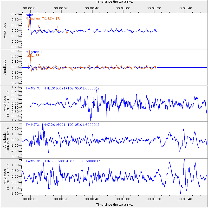
Signal To Noise
| Channel | StoN | STA | LTA |
| TA:MSTX: :HHZ:20160914T02:05:01.600001Z | 6.1966834 | 5.8824054E-7 | 9.492828E-8 |
| TA:MSTX: :HHN:20160914T02:05:01.600001Z | 1.5450643 | 2.5451214E-7 | 1.6472592E-7 |
| TA:MSTX: :HHE:20160914T02:05:01.600001Z | 2.2328103 | 2.7477742E-7 | 1.2306349E-7 |
| Arrivals |
| Ps | 6.6 SECOND |
| PpPs | 23 SECOND |
| PsPs/PpSs | 30 SECOND |


