You are here: Home > Network List > AV - Alaska Volcano Observatory Stations List
> Station SPCR Ckakachatna River, Mount Spurr, Alaska > Earthquake Result Viewer
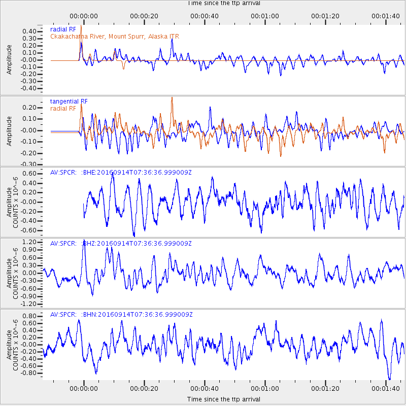
SPCR Ckakachatna River, Mount Spurr, Alaska - Earthquake Result Viewer
*The percent match for this event was below the threshold and hence no stack was calculated.
| Earthquake location: |
Solomon Islands |
| Earthquake latitude/longitude: |
-9.4/159.1 |
| Earthquake time(UTC): |
2016/09/14 (258) 07:24:59 GMT |
| Earthquake Depth: |
10 km |
| Earthquake Magnitude: |
6.0 MWB |
| Earthquake Catalog/Contributor: |
NEIC PDE/NEIC COMCAT |
|
| Network: |
AV Alaska Volcano Observatory |
| Station: |
SPCR Ckakachatna River, Mount Spurr, Alaska |
| Lat/Lon: |
61.20 N/152.21 W |
| Elevation: |
984 m |
|
| Distance: |
80.0 deg |
| Az: |
21.662 deg |
| Baz: |
228.786 deg |
| Ray Param: |
$rayparam |
*The percent match for this event was below the threshold and hence was not used in the summary stack. |
|
| Radial Match: |
63.261047 % |
| Radial Bump: |
383 |
| Transverse Match: |
56.444668 % |
| Transverse Bump: |
400 |
| SOD ConfigId: |
11737051 |
| Insert Time: |
2019-04-25 12:47:12.384 +0000 |
| GWidth: |
2.5 |
| Max Bumps: |
400 |
| Tol: |
0.001 |
|
Signal To Noise
| Channel | StoN | STA | LTA |
| AV:SPCR: :BHZ:20160914T07:36:36.999009Z | 3.1946654 | 5.806184E-7 | 1.8174623E-7 |
| AV:SPCR: :BHN:20160914T07:36:36.999009Z | 2.6516786 | 4.1435598E-7 | 1.5626178E-7 |
| AV:SPCR: :BHE:20160914T07:36:36.999009Z | 0.84103507 | 2.5074013E-7 | 2.9813276E-7 |
| Arrivals |
| Ps | |
| PpPs | |
| PsPs/PpSs | |


