You are here: Home > Network List > TA - USArray Transportable Network (new EarthScope stations) Stations List
> Station A36M Sachs Harbour, NT, CAN > Earthquake Result Viewer
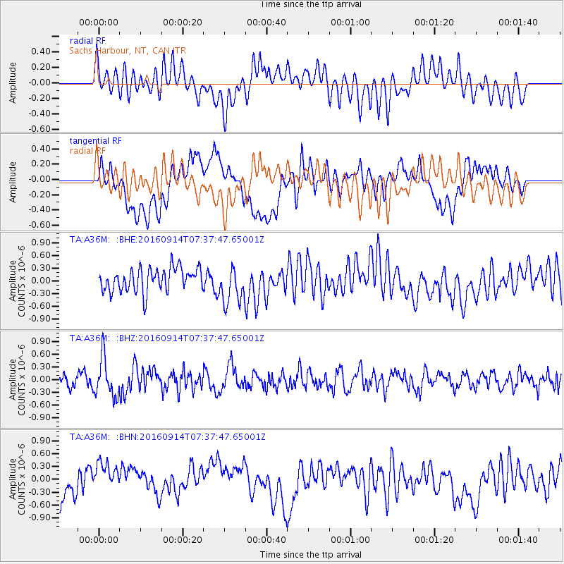
A36M Sachs Harbour, NT, CAN - Earthquake Result Viewer
*The percent match for this event was below the threshold and hence no stack was calculated.
| Earthquake location: |
Solomon Islands |
| Earthquake latitude/longitude: |
-9.4/159.1 |
| Earthquake time(UTC): |
2016/09/14 (258) 07:24:59 GMT |
| Earthquake Depth: |
10 km |
| Earthquake Magnitude: |
6.0 MWB |
| Earthquake Catalog/Contributor: |
NEIC PDE/NEIC COMCAT |
|
| Network: |
TA USArray Transportable Network (new EarthScope stations) |
| Station: |
A36M Sachs Harbour, NT, CAN |
| Lat/Lon: |
71.99 N/125.25 W |
| Elevation: |
32 m |
|
| Distance: |
94.4 deg |
| Az: |
17.593 deg |
| Baz: |
253.484 deg |
| Ray Param: |
$rayparam |
*The percent match for this event was below the threshold and hence was not used in the summary stack. |
|
| Radial Match: |
51.88329 % |
| Radial Bump: |
400 |
| Transverse Match: |
42.46563 % |
| Transverse Bump: |
400 |
| SOD ConfigId: |
11737051 |
| Insert Time: |
2019-04-25 12:51:52.487 +0000 |
| GWidth: |
2.5 |
| Max Bumps: |
400 |
| Tol: |
0.001 |
|
Signal To Noise
| Channel | StoN | STA | LTA |
| TA:A36M: :BHZ:20160914T07:37:47.65001Z | 4.2372274 | 4.6692873E-7 | 1.10196765E-7 |
| TA:A36M: :BHN:20160914T07:37:47.65001Z | 0.7871611 | 3.7668622E-7 | 4.7853763E-7 |
| TA:A36M: :BHE:20160914T07:37:47.65001Z | 1.9144492 | 5.2192837E-7 | 2.7262584E-7 |
| Arrivals |
| Ps | |
| PpPs | |
| PsPs/PpSs | |


