You are here: Home > Network List > TA - USArray Transportable Network (new EarthScope stations) Stations List
> Station F26K Sheenjek River, AK, USA > Earthquake Result Viewer
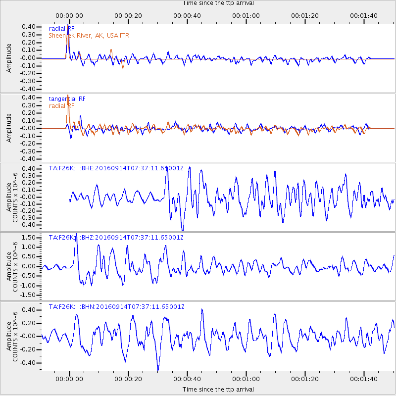
F26K Sheenjek River, AK, USA - Earthquake Result Viewer

| Earthquake location: |
Solomon Islands |
| Earthquake latitude/longitude: |
-9.4/159.1 |
| Earthquake time(UTC): |
2016/09/14 (258) 07:24:59 GMT |
| Earthquake Depth: |
10 km |
| Earthquake Magnitude: |
6.0 MWB |
| Earthquake Catalog/Contributor: |
NEIC PDE/NEIC COMCAT |
|
| Network: |
TA USArray Transportable Network (new EarthScope stations) |
| Station: |
F26K Sheenjek River, AK, USA |
| Lat/Lon: |
67.69 N/144.15 W |
| Elevation: |
683 m |
|
| Distance: |
86.7 deg |
| Az: |
18.639 deg |
| Baz: |
235.715 deg |
| Ray Param: |
0.04385016 |
| Estimated Moho Depth: |
17.25 km |
| Estimated Crust Vp/Vs: |
1.77 |
| Assumed Crust Vp: |
6.522 km/s |
| Estimated Crust Vs: |
3.685 km/s |
| Estimated Crust Poisson's Ratio: |
0.27 |
|
| Radial Match: |
86.5675 % |
| Radial Bump: |
400 |
| Transverse Match: |
70.74286 % |
| Transverse Bump: |
379 |
| SOD ConfigId: |
11737051 |
| Insert Time: |
2019-04-25 12:52:05.114 +0000 |
| GWidth: |
2.5 |
| Max Bumps: |
400 |
| Tol: |
0.001 |
|
Signal To Noise
| Channel | StoN | STA | LTA |
| TA:F26K: :BHZ:20160914T07:37:11.65001Z | 8.709615 | 7.525269E-7 | 8.6401855E-8 |
| TA:F26K: :BHN:20160914T07:37:11.65001Z | 2.6720512 | 1.7419443E-7 | 6.519128E-8 |
| TA:F26K: :BHE:20160914T07:37:11.65001Z | 2.8055217 | 1.8988555E-7 | 6.768279E-8 |
| Arrivals |
| Ps | 2.1 SECOND |
| PpPs | 7.2 SECOND |
| PsPs/PpSs | 9.2 SECOND |


