You are here: Home > Network List > TA - USArray Transportable Network (new EarthScope stations) Stations List
> Station G26K Porcupine River, AK, USA > Earthquake Result Viewer
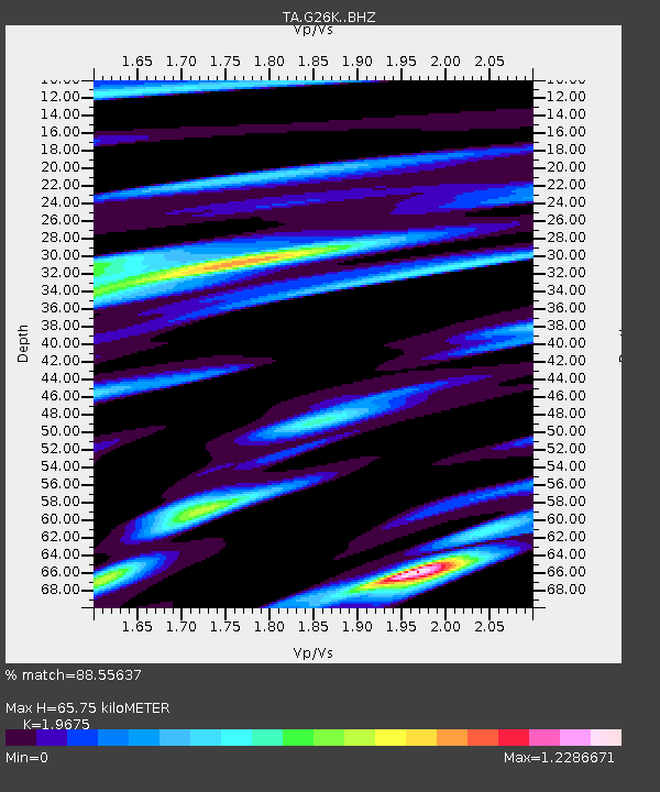
G26K Porcupine River, AK, USA - Earthquake Result Viewer
| Earthquake location: |
Solomon Islands |
| Earthquake latitude/longitude: |
-9.4/159.1 |
| Earthquake time(UTC): |
2016/09/14 (258) 07:24:59 GMT |
| Earthquake Depth: |
10 km |
| Earthquake Magnitude: |
6.0 MWB |
| Earthquake Catalog/Contributor: |
NEIC PDE/NEIC COMCAT |
|
| Network: |
TA USArray Transportable Network (new EarthScope stations) |
| Station: |
G26K Porcupine River, AK, USA |
| Lat/Lon: |
66.95 N/143.78 W |
| Elevation: |
180 m |
|
| Distance: |
86.4 deg |
| Az: |
19.339 deg |
| Baz: |
236.089 deg |
| Ray Param: |
0.044070963 |
| Estimated Moho Depth: |
65.75 km |
| Estimated Crust Vp/Vs: |
1.97 |
| Assumed Crust Vp: |
6.577 km/s |
| Estimated Crust Vs: |
3.343 km/s |
| Estimated Crust Poisson's Ratio: |
0.33 |
|
| Radial Match: |
88.55637 % |
| Radial Bump: |
382 |
| Transverse Match: |
83.92058 % |
| Transverse Bump: |
326 |
| SOD ConfigId: |
11737051 |
| Insert Time: |
2019-04-25 12:52:11.809 +0000 |
| GWidth: |
2.5 |
| Max Bumps: |
400 |
| Tol: |
0.001 |
|

Signal To Noise
| Channel | StoN | STA | LTA |
| TA:G26K: :BHZ:20160914T07:37:10.174973Z | 15.040603 | 9.591311E-7 | 6.3769455E-8 |
| TA:G26K: :BHN:20160914T07:37:10.174973Z | 3.7346306 | 3.8808477E-7 | 1.0391517E-7 |
| TA:G26K: :BHE:20160914T07:37:10.174973Z | 3.940983 | 4.2792232E-7 | 1.0858263E-7 |
| Arrivals |
| Ps | 9.9 SECOND |
| PpPs | 29 SECOND |
| PsPs/PpSs | 39 SECOND |


