You are here: Home > Network List > TA - USArray Transportable Network (new EarthScope stations) Stations List
> Station J20K Nowitna River, AK, USA > Earthquake Result Viewer
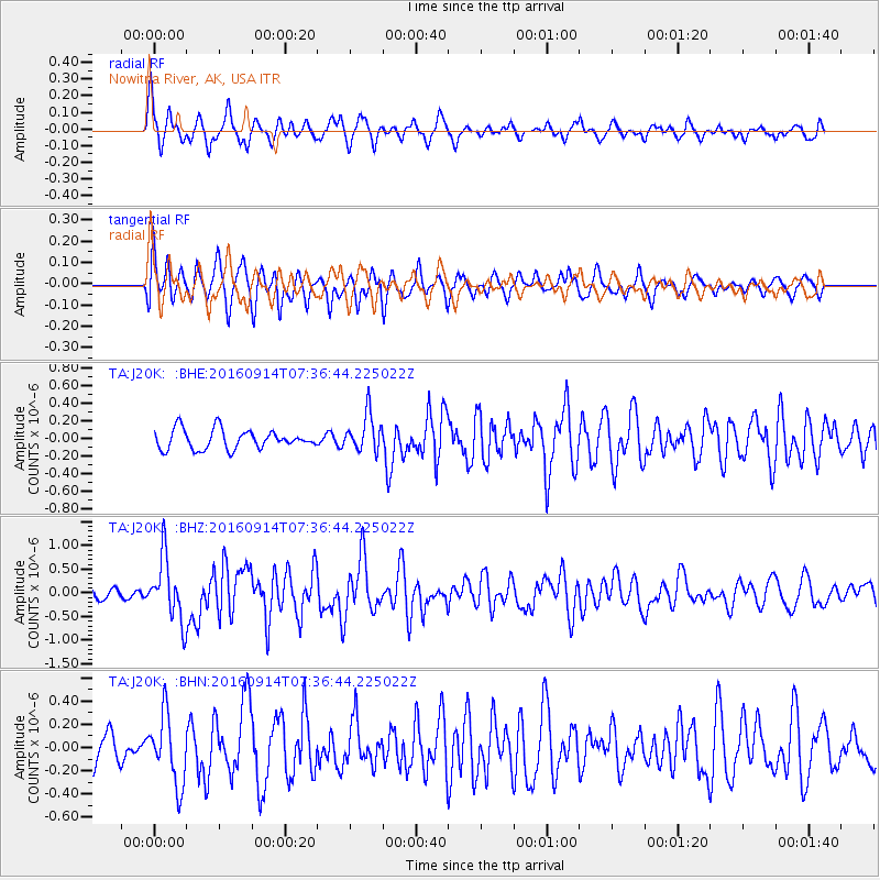
J20K Nowitna River, AK, USA - Earthquake Result Viewer
*The percent match for this event was below the threshold and hence no stack was calculated.
| Earthquake location: |
Solomon Islands |
| Earthquake latitude/longitude: |
-9.4/159.1 |
| Earthquake time(UTC): |
2016/09/14 (258) 07:24:59 GMT |
| Earthquake Depth: |
10 km |
| Earthquake Magnitude: |
6.0 MWB |
| Earthquake Catalog/Contributor: |
NEIC PDE/NEIC COMCAT |
|
| Network: |
TA USArray Transportable Network (new EarthScope stations) |
| Station: |
J20K Nowitna River, AK, USA |
| Lat/Lon: |
64.18 N/154.15 W |
| Elevation: |
314 m |
|
| Distance: |
81.3 deg |
| Az: |
18.813 deg |
| Baz: |
226.603 deg |
| Ray Param: |
$rayparam |
*The percent match for this event was below the threshold and hence was not used in the summary stack. |
|
| Radial Match: |
64.84614 % |
| Radial Bump: |
368 |
| Transverse Match: |
68.97226 % |
| Transverse Bump: |
315 |
| SOD ConfigId: |
11737051 |
| Insert Time: |
2019-04-25 12:52:27.834 +0000 |
| GWidth: |
2.5 |
| Max Bumps: |
400 |
| Tol: |
0.001 |
|
Signal To Noise
| Channel | StoN | STA | LTA |
| TA:J20K: :BHZ:20160914T07:36:44.225022Z | 5.6162176 | 6.6823117E-7 | 1.1898242E-7 |
| TA:J20K: :BHN:20160914T07:36:44.225022Z | 2.4722166 | 2.942346E-7 | 1.1901652E-7 |
| TA:J20K: :BHE:20160914T07:36:44.225022Z | 2.1149437 | 2.3174279E-7 | 1.0957398E-7 |
| Arrivals |
| Ps | |
| PpPs | |
| PsPs/PpSs | |


