You are here: Home > Network List > TA - USArray Transportable Network (new EarthScope stations) Stations List
> Station J26L Joseph Creek, AK, USA > Earthquake Result Viewer
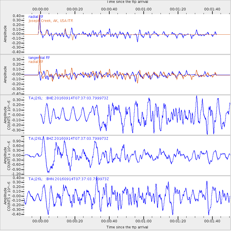
J26L Joseph Creek, AK, USA - Earthquake Result Viewer
*The percent match for this event was below the threshold and hence no stack was calculated.
| Earthquake location: |
Solomon Islands |
| Earthquake latitude/longitude: |
-9.4/159.1 |
| Earthquake time(UTC): |
2016/09/14 (258) 07:24:59 GMT |
| Earthquake Depth: |
10 km |
| Earthquake Magnitude: |
6.0 MWB |
| Earthquake Catalog/Contributor: |
NEIC PDE/NEIC COMCAT |
|
| Network: |
TA USArray Transportable Network (new EarthScope stations) |
| Station: |
J26L Joseph Creek, AK, USA |
| Lat/Lon: |
64.50 N/143.56 W |
| Elevation: |
1144 m |
|
| Distance: |
85.1 deg |
| Az: |
21.441 deg |
| Baz: |
236.446 deg |
| Ray Param: |
$rayparam |
*The percent match for this event was below the threshold and hence was not used in the summary stack. |
|
| Radial Match: |
76.36819 % |
| Radial Bump: |
400 |
| Transverse Match: |
56.6109 % |
| Transverse Bump: |
400 |
| SOD ConfigId: |
11737051 |
| Insert Time: |
2019-04-25 12:52:28.284 +0000 |
| GWidth: |
2.5 |
| Max Bumps: |
400 |
| Tol: |
0.001 |
|
Signal To Noise
| Channel | StoN | STA | LTA |
| TA:J26L: :BHZ:20160914T07:37:03.799973Z | 6.83188 | 7.099911E-7 | 1.0392324E-7 |
| TA:J26L: :BHN:20160914T07:37:03.799973Z | 2.036855 | 1.9834962E-7 | 9.738034E-8 |
| TA:J26L: :BHE:20160914T07:37:03.799973Z | 1.6745639 | 1.6938063E-7 | 1.011491E-7 |
| Arrivals |
| Ps | |
| PpPs | |
| PsPs/PpSs | |


