You are here: Home > Network List > TA - USArray Transportable Network (new EarthScope stations) Stations List
> Station N31M Braeburn, Yukon, CA > Earthquake Result Viewer
N31M Braeburn, Yukon, CA - Earthquake Result Viewer
| Earthquake location: |
Solomon Islands |
| Earthquake latitude/longitude: |
-9.4/159.1 |
| Earthquake time(UTC): |
2016/09/14 (258) 07:24:59 GMT |
| Earthquake Depth: |
10 km |
| Earthquake Magnitude: |
6.0 MWB |
| Earthquake Catalog/Contributor: |
NEIC PDE/NEIC COMCAT |
|
| Network: |
TA USArray Transportable Network (new EarthScope stations) |
| Station: |
N31M Braeburn, Yukon, CA |
| Lat/Lon: |
61.49 N/135.78 W |
| Elevation: |
716 m |
|
| Distance: |
86.7 deg |
| Az: |
25.841 deg |
| Baz: |
243.691 deg |
| Ray Param: |
0.043866187 |
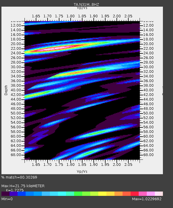
| Estimated Moho Depth: |
21.75 km |
| Estimated Crust Vp/Vs: |
1.73 |
| Assumed Crust Vp: |
6.419 km/s |
| Estimated Crust Vs: |
3.716 km/s |
| Estimated Crust Poisson's Ratio: |
0.25 |
|
| Radial Match: |
80.30269 % |
| Radial Bump: |
400 |
| Transverse Match: |
66.38927 % |
| Transverse Bump: |
400 |
| SOD ConfigId: |
11737051 |
| Insert Time: |
2019-04-25 12:52:54.093 +0000 |
| GWidth: |
2.5 |
| Max Bumps: |
400 |
| Tol: |
0.001 |
|

Signal To Noise
| Channel | StoN | STA | LTA |
| TA:N31M: :BHZ:20160914T07:37:11.549973Z | 4.1293635 | 1.0432797E-6 | 2.5264904E-7 |
| TA:N31M: :BHN:20160914T07:37:11.549973Z | 1.0947906 | 2.480446E-7 | 2.265681E-7 |
| TA:N31M: :BHE:20160914T07:37:11.549973Z | 3.166711 | 4.6165562E-7 | 1.4578393E-7 |
| Arrivals |
| Ps | 2.5 SECOND |
| PpPs | 9.0 SECOND |
| PsPs/PpSs | 12 SECOND |


