You are here: Home > Network List > UW - Pacific Northwest Regional Seismic Network Stations List
> Station MRBL Marblemount, WA, USA > Earthquake Result Viewer
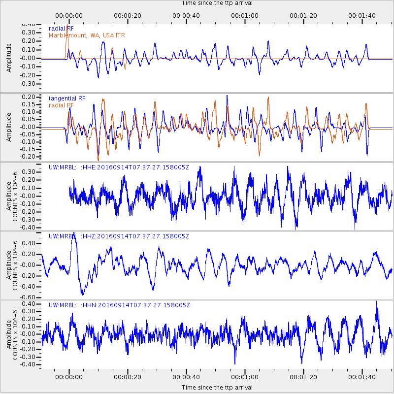
MRBL Marblemount, WA, USA - Earthquake Result Viewer
*The percent match for this event was below the threshold and hence no stack was calculated.
| Earthquake location: |
Solomon Islands |
| Earthquake latitude/longitude: |
-9.4/159.1 |
| Earthquake time(UTC): |
2016/09/14 (258) 07:24:59 GMT |
| Earthquake Depth: |
10 km |
| Earthquake Magnitude: |
6.0 MWB |
| Earthquake Catalog/Contributor: |
NEIC PDE/NEIC COMCAT |
|
| Network: |
UW Pacific Northwest Regional Seismic Network |
| Station: |
MRBL Marblemount, WA, USA |
| Lat/Lon: |
48.52 N/121.48 W |
| Elevation: |
75 m |
|
| Distance: |
90.0 deg |
| Az: |
40.803 deg |
| Baz: |
255.907 deg |
| Ray Param: |
$rayparam |
*The percent match for this event was below the threshold and hence was not used in the summary stack. |
|
| Radial Match: |
48.458263 % |
| Radial Bump: |
400 |
| Transverse Match: |
67.636314 % |
| Transverse Bump: |
400 |
| SOD ConfigId: |
11737051 |
| Insert Time: |
2019-04-25 12:53:51.760 +0000 |
| GWidth: |
2.5 |
| Max Bumps: |
400 |
| Tol: |
0.001 |
|
Signal To Noise
| Channel | StoN | STA | LTA |
| UW:MRBL: :HHZ:20160914T07:37:27.158005Z | 3.1755476 | 3.768074E-7 | 1.1865903E-7 |
| UW:MRBL: :HHN:20160914T07:37:27.158005Z | 1.3036894 | 1.3540118E-7 | 1.03859996E-7 |
| UW:MRBL: :HHE:20160914T07:37:27.158005Z | 1.216803 | 1.2063454E-7 | 9.914058E-8 |
| Arrivals |
| Ps | |
| PpPs | |
| PsPs/PpSs | |


