You are here: Home > Network List > US - United States National Seismic Network Stations List
> Station LTX Lajitas, Texas, USA > Earthquake Result Viewer
LTX Lajitas, Texas, USA - Earthquake Result Viewer
| Earthquake location: |
South Of Fiji Islands |
| Earthquake latitude/longitude: |
-23.8/-176.0 |
| Earthquake time(UTC): |
2004/03/18 (078) 20:04:24 GMT |
| Earthquake Depth: |
10 km |
| Earthquake Magnitude: |
5.8 MB, 6.1 MS, 6.2 MW, 6.0 MW |
| Earthquake Catalog/Contributor: |
WHDF/NEIC |
|
| Network: |
US United States National Seismic Network |
| Station: |
LTX Lajitas, Texas, USA |
| Lat/Lon: |
29.33 N/103.67 W |
| Elevation: |
1013 m |
|
| Distance: |
87.3 deg |
| Az: |
56.403 deg |
| Baz: |
240.93 deg |
| Ray Param: |
0.043438237 |
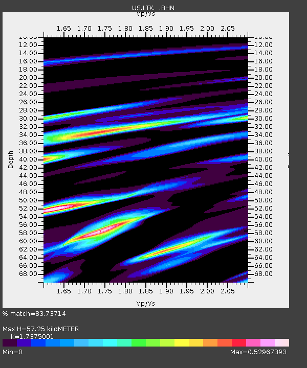
| Estimated Moho Depth: |
57.25 km |
| Estimated Crust Vp/Vs: |
1.74 |
| Assumed Crust Vp: |
6.419 km/s |
| Estimated Crust Vs: |
3.695 km/s |
| Estimated Crust Poisson's Ratio: |
0.25 |
|
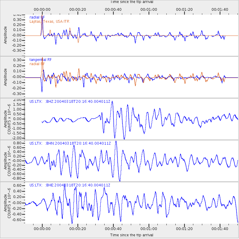
| Radial Match: |
83.73714 % |
| Radial Bump: |
400 |
| Transverse Match: |
80.80381 % |
| Transverse Bump: |
357 |
| SOD ConfigId: |
110177 |
| Insert Time: |
2010-03-05 07:01:01.402 +0000 |
| GWidth: |
2.5 |
| Max Bumps: |
400 |
| Tol: |
0.001 |
|
Signal To Noise
| Channel | StoN | STA | LTA |
| US:LTX: :BHN:20040318T20:16:40.004011Z | 3.245326 | 1.8251072E-7 | 5.6238022E-8 |
| US:LTX: :BHE:20040318T20:16:40.004011Z | 1.5811468 | 1.1929775E-7 | 7.545014E-8 |
| US:LTX: :BHZ:20040318T20:16:40.004011Z | 3.2099879 | 5.343875E-7 | 1.6647648E-7 |
| Arrivals |
| Ps | 6.7 SECOND |
| PpPs | 24 SECOND |
| PsPs/PpSs | 31 SECOND |


