You are here: Home > Network List > US - United States National Seismic Network Stations List
> Station LTX Lajitas, Texas, USA > Earthquake Result Viewer
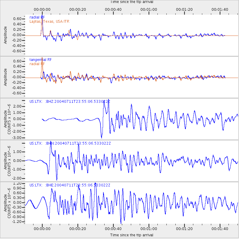
LTX Lajitas, Texas, USA - Earthquake Result Viewer
| Earthquake location: |
South Pacific Ocean |
| Earthquake latitude/longitude: |
-20.3/-126.9 |
| Earthquake time(UTC): |
2004/07/11 (193) 23:46:12 GMT |
| Earthquake Depth: |
12 km |
| Earthquake Magnitude: |
6.1 MB, 5.9 MS, 6.1 MW, 6.1 MW |
| Earthquake Catalog/Contributor: |
WHDF/NEIC |
|
| Network: |
US United States National Seismic Network |
| Station: |
LTX Lajitas, Texas, USA |
| Lat/Lon: |
29.33 N/103.67 W |
| Elevation: |
1013 m |
|
| Distance: |
54.2 deg |
| Az: |
25.174 deg |
| Baz: |
207.219 deg |
| Ray Param: |
0.06561555 |
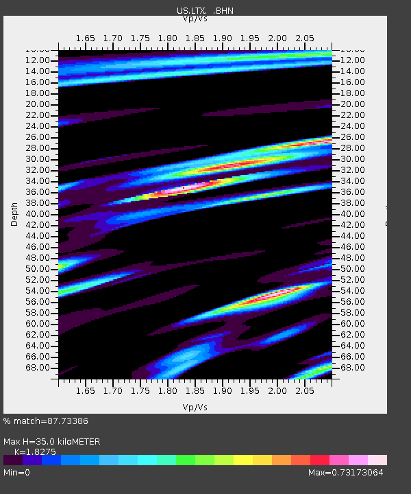
| Estimated Moho Depth: |
35.0 km |
| Estimated Crust Vp/Vs: |
1.83 |
| Assumed Crust Vp: |
6.419 km/s |
| Estimated Crust Vs: |
3.513 km/s |
| Estimated Crust Poisson's Ratio: |
0.29 |
|
| Radial Match: |
87.73386 % |
| Radial Bump: |
400 |
| Transverse Match: |
74.2613 % |
| Transverse Bump: |
400 |
| SOD ConfigId: |
110177 |
| Insert Time: |
2010-03-05 07:01:08.953 +0000 |
| GWidth: |
2.5 |
| Max Bumps: |
400 |
| Tol: |
0.001 |
|
Signal To Noise
| Channel | StoN | STA | LTA |
| US:LTX: :BHN:20040711T23:55:06.533022Z | 5.859769 | 7.8086094E-7 | 1.3325798E-7 |
| US:LTX: :BHE:20040711T23:55:06.533022Z | 4.6136594 | 4.435919E-7 | 9.6147524E-8 |
| US:LTX: :BHZ:20040711T23:55:06.533022Z | 9.527349 | 1.3555047E-6 | 1.4227511E-7 |
| Arrivals |
| Ps | 4.8 SECOND |
| PpPs | 15 SECOND |
| PsPs/PpSs | 19 SECOND |


