You are here: Home > Network List > US - United States National Seismic Network Stations List
> Station LTX Lajitas, Texas, USA > Earthquake Result Viewer
LTX Lajitas, Texas, USA - Earthquake Result Viewer
| Earthquake location: |
South Of Aleutian Islands |
| Earthquake latitude/longitude: |
51.8/-166.3 |
| Earthquake time(UTC): |
2004/08/07 (220) 09:30:16 GMT |
| Earthquake Depth: |
8.0 km |
| Earthquake Magnitude: |
6.3 MB, 5.4 MS, 6.0 MW, 6.0 MW |
| Earthquake Catalog/Contributor: |
WHDF/NEIC |
|
| Network: |
US United States National Seismic Network |
| Station: |
LTX Lajitas, Texas, USA |
| Lat/Lon: |
29.33 N/103.67 W |
| Elevation: |
1013 m |
|
| Distance: |
50.9 deg |
| Az: |
90.835 deg |
| Baz: |
314.616 deg |
| Ray Param: |
0.06777866 |
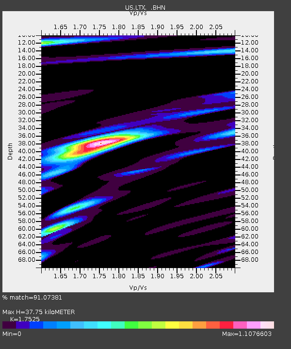
| Estimated Moho Depth: |
37.75 km |
| Estimated Crust Vp/Vs: |
1.75 |
| Assumed Crust Vp: |
6.419 km/s |
| Estimated Crust Vs: |
3.663 km/s |
| Estimated Crust Poisson's Ratio: |
0.26 |
|
| Radial Match: |
91.07381 % |
| Radial Bump: |
400 |
| Transverse Match: |
82.43441 % |
| Transverse Bump: |
400 |
| SOD ConfigId: |
110177 |
| Insert Time: |
2010-03-05 07:01:10.323 +0000 |
| GWidth: |
2.5 |
| Max Bumps: |
400 |
| Tol: |
0.001 |
|
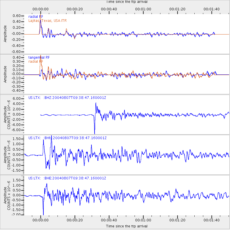
Signal To Noise
| Channel | StoN | STA | LTA |
| US:LTX: :BHN:20040807T09:38:47.160001Z | 10.003783 | 6.3639106E-7 | 6.361504E-8 |
| US:LTX: :BHE:20040807T09:38:47.160001Z | 9.363137 | 6.169859E-7 | 6.5895215E-8 |
| US:LTX: :BHZ:20040807T09:38:47.160001Z | 23.907022 | 2.2419995E-6 | 9.377995E-8 |
| Arrivals |
| Ps | 4.7 SECOND |
| PpPs | 15 SECOND |
| PsPs/PpSs | 20 SECOND |


