You are here: Home > Network List > US - United States National Seismic Network Stations List
> Station LTX Lajitas, Texas, USA > Earthquake Result Viewer
LTX Lajitas, Texas, USA - Earthquake Result Viewer
| Earthquake location: |
Near Coast Of Northern Chile |
| Earthquake latitude/longitude: |
-27.4/-70.8 |
| Earthquake time(UTC): |
2004/08/27 (240) 00:43:54 GMT |
| Earthquake Depth: |
30 km |
| Earthquake Magnitude: |
5.8 MB, 5.4 MS, 5.9 MW, 5.8 MW |
| Earthquake Catalog/Contributor: |
WHDF/NEIC |
|
| Network: |
US United States National Seismic Network |
| Station: |
LTX Lajitas, Texas, USA |
| Lat/Lon: |
29.33 N/103.67 W |
| Elevation: |
1013 m |
|
| Distance: |
64.6 deg |
| Az: |
328.369 deg |
| Baz: |
147.731 deg |
| Ray Param: |
0.05876416 |
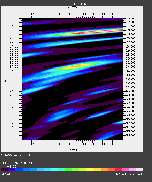
| Estimated Moho Depth: |
16.25 km |
| Estimated Crust Vp/Vs: |
1.99 |
| Assumed Crust Vp: |
6.419 km/s |
| Estimated Crust Vs: |
3.226 km/s |
| Estimated Crust Poisson's Ratio: |
0.33 |
|
| Radial Match: |
87.838196 % |
| Radial Bump: |
395 |
| Transverse Match: |
73.04696 % |
| Transverse Bump: |
400 |
| SOD ConfigId: |
110177 |
| Insert Time: |
2010-03-05 07:01:12.415 +0000 |
| GWidth: |
2.5 |
| Max Bumps: |
400 |
| Tol: |
0.001 |
|
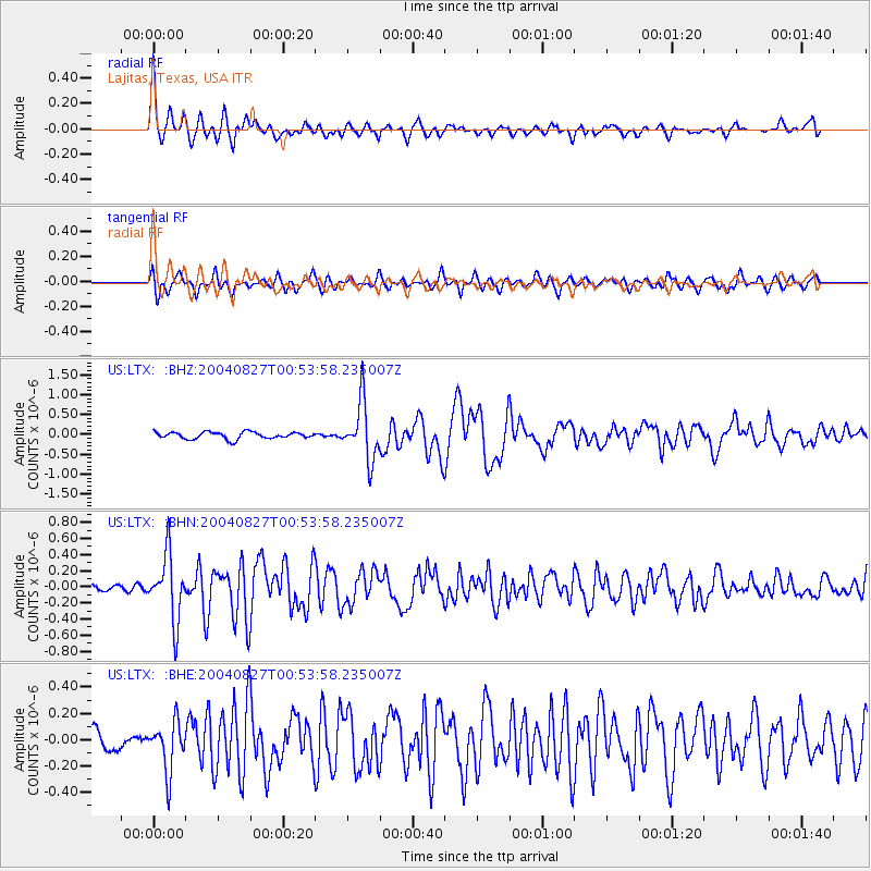
Signal To Noise
| Channel | StoN | STA | LTA |
| US:LTX: :BHN:20040827T00:53:58.235007Z | 7.637125 | 4.028194E-7 | 5.2744902E-8 |
| US:LTX: :BHE:20040827T00:53:58.235007Z | 2.0757284 | 1.8812172E-7 | 9.062925E-8 |
| US:LTX: :BHZ:20040827T00:53:58.235007Z | 8.365184 | 7.1798684E-7 | 8.583037E-8 |
| Arrivals |
| Ps | 2.6 SECOND |
| PpPs | 7.3 SECOND |
| PsPs/PpSs | 9.9 SECOND |


