You are here: Home > Network List > US - United States National Seismic Network Stations List
> Station LTX Lajitas, Texas, USA > Earthquake Result Viewer
LTX Lajitas, Texas, USA - Earthquake Result Viewer
| Earthquake location: |
Chile-Argentina Border Region |
| Earthquake latitude/longitude: |
-34.9/-70.4 |
| Earthquake time(UTC): |
2004/08/28 (241) 13:41:27 GMT |
| Earthquake Depth: |
1.0 km |
| Earthquake Magnitude: |
6.1 MB, 6.3 MS, 6.5 MW, 6.5 MW |
| Earthquake Catalog/Contributor: |
WHDF/NEIC |
|
| Network: |
US United States National Seismic Network |
| Station: |
LTX Lajitas, Texas, USA |
| Lat/Lon: |
29.33 N/103.67 W |
| Elevation: |
1013 m |
|
| Distance: |
71.2 deg |
| Az: |
329.596 deg |
| Baz: |
151.561 deg |
| Ray Param: |
0.05448666 |
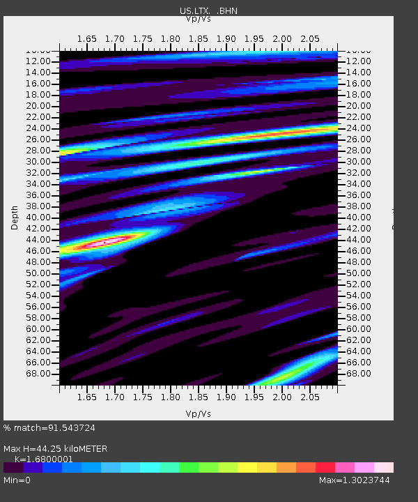
| Estimated Moho Depth: |
44.25 km |
| Estimated Crust Vp/Vs: |
1.68 |
| Assumed Crust Vp: |
6.419 km/s |
| Estimated Crust Vs: |
3.821 km/s |
| Estimated Crust Poisson's Ratio: |
0.23 |
|
| Radial Match: |
91.543724 % |
| Radial Bump: |
400 |
| Transverse Match: |
80.993034 % |
| Transverse Bump: |
400 |
| SOD ConfigId: |
110177 |
| Insert Time: |
2010-03-05 07:01:13.798 +0000 |
| GWidth: |
2.5 |
| Max Bumps: |
400 |
| Tol: |
0.001 |
|
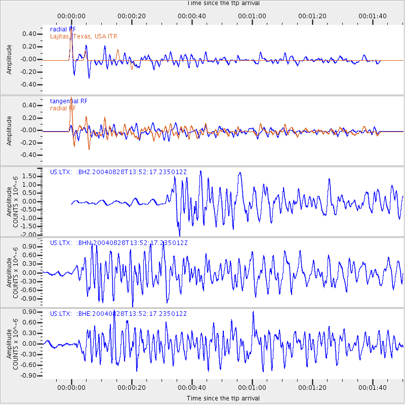
Signal To Noise
| Channel | StoN | STA | LTA |
| US:LTX: :BHN:20040828T13:52:17.235012Z | 3.5828655 | 2.0986606E-7 | 5.8574923E-8 |
| US:LTX: :BHE:20040828T13:52:17.235012Z | 2.4076242 | 1.5226661E-7 | 6.3243505E-8 |
| US:LTX: :BHZ:20040828T13:52:17.235012Z | 5.910132 | 5.4212563E-7 | 9.1728175E-8 |
| Arrivals |
| Ps | 4.9 SECOND |
| PpPs | 18 SECOND |
| PsPs/PpSs | 23 SECOND |


