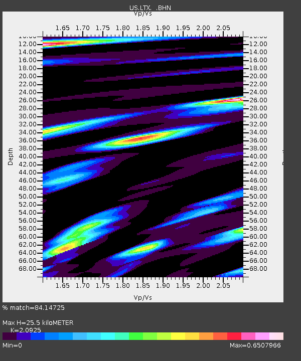
LTX Lajitas, Texas, USA - Earthquake Result Viewer
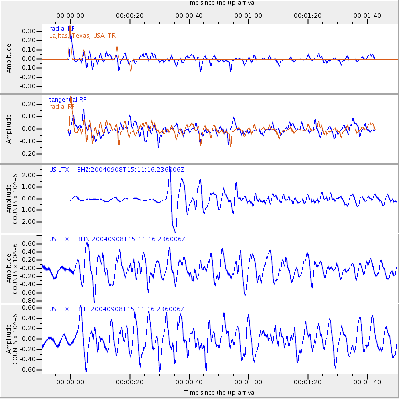
Earthquake location: Near S. Coast Of Honshu, Japan
Earthquake latitude/longitude: 33.1/137.2
Earthquake time(UTC): 2004/09/08 (252) 14:58:25 GMT
Earthquake Depth: 21 km
Earthquake Magnitude: 6.2 MB, 5.8 MS, 6.2 MW, 6.1 MW
Earthquake Catalog/Contributor: WHDF/NEIC
Network: US United States National Seismic Network
Station: LTX Lajitas, Texas, USA
Lat/Lon: 29.33 N/103.67 W
Elevation: 1013 m
Distance: 95.2 deg
Az: 49.989 deg
Baz: 312.612 deg
Ray Param: 0.040826224
Estimated Moho Depth: 25.5 km
Estimated Crust Vp/Vs: 2.09
Assumed Crust Vp: 6.419 km/s
Estimated Crust Vs: 3.068 km/s
Estimated Crust Poisson's Ratio: 0.35
Radial Match: 84.14725 %
Radial Bump: 400
Transverse Match: 81.8916 %
Transverse Bump: 400
SOD ConfigId: 110177
Insert Time: 2010-03-05 07:01:22.608 +0000
GWidth: 2.5
Max Bumps: 400
Tol: 0.001

Signal To Noise

ChannelStoNSTALTA
US:LTX: :BHN:20040908T15:11:16.236006Z1.93574041.7577183E-79.080341E-8
US:LTX: :BHE:20040908T15:11:16.236006Z3.03646142.564233E-78.444807E-8
US:LTX: :BHZ:20040908T15:11:16.236006Z10.5824671.2053896E-61.13904406E-7
Arrivals
Ps4.4 SECOND
PpPs12 SECOND
PsPs/PpSs16 SECOND