You are here: Home > Network List > US - United States National Seismic Network Stations List
> Station MSO Missoula, Montana, USA > Earthquake Result Viewer
MSO Missoula, Montana, USA - Earthquake Result Viewer
*The percent match for this event was below the threshold and hence no stack was calculated.
| Earthquake location: |
Nicaragua |
| Earthquake latitude/longitude: |
12.4/-86.6 |
| Earthquake time(UTC): |
2016/09/15 (259) 05:57:24 GMT |
| Earthquake Depth: |
10 km |
| Earthquake Magnitude: |
5.7 mww |
| Earthquake Catalog/Contributor: |
NEIC PDE/us |
|
| Network: |
US United States National Seismic Network |
| Station: |
MSO Missoula, Montana, USA |
| Lat/Lon: |
46.83 N/113.94 W |
| Elevation: |
1264 m |
|
| Distance: |
41.3 deg |
| Az: |
331.484 deg |
| Baz: |
137.219 deg |
| Ray Param: |
$rayparam |
*The percent match for this event was below the threshold and hence was not used in the summary stack. |
|
| Radial Match: |
65.67311 % |
| Radial Bump: |
400 |
| Transverse Match: |
52.454857 % |
| Transverse Bump: |
400 |
| SOD ConfigId: |
11737051 |
| Insert Time: |
2019-04-25 13:01:45.208 +0000 |
| GWidth: |
2.5 |
| Max Bumps: |
400 |
| Tol: |
0.001 |
|
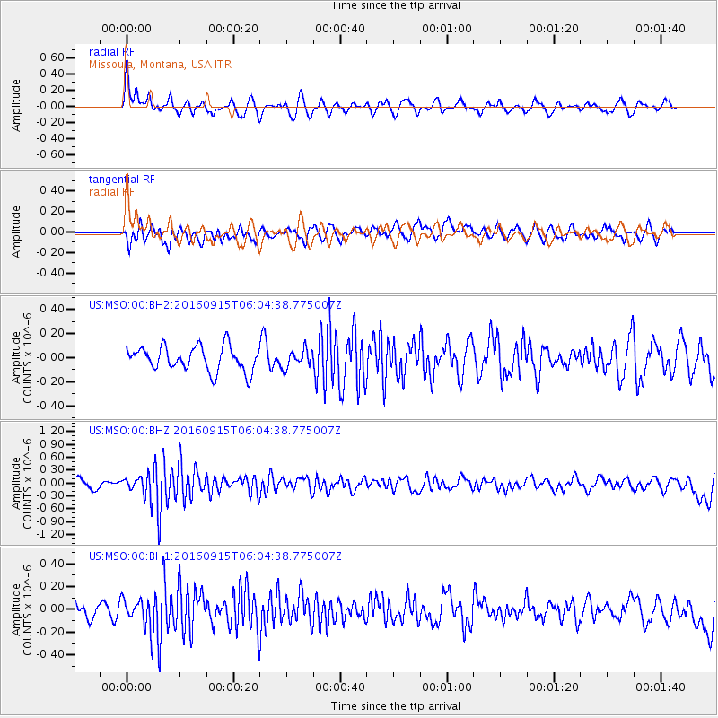
Signal To Noise
| Channel | StoN | STA | LTA |
| US:MSO:00:BHZ:20160915T06:04:38.775007Z | 2.5325963 | 2.4085006E-7 | 9.510006E-8 |
| US:MSO:00:BH1:20160915T06:04:38.775007Z | 1.5478384 | 1.3475582E-7 | 8.7060656E-8 |
| US:MSO:00:BH2:20160915T06:04:38.775007Z | 0.72061443 | 7.3100175E-8 | 1.0144146E-7 |
| Arrivals |
| Ps | |
| PpPs | |
| PsPs/PpSs | |


