You are here: Home > Network List > US - United States National Seismic Network Stations List
> Station LTX Lajitas, Texas, USA > Earthquake Result Viewer
LTX Lajitas, Texas, USA - Earthquake Result Viewer
| Earthquake location: |
Leeward Islands |
| Earthquake latitude/longitude: |
15.7/-61.7 |
| Earthquake time(UTC): |
2004/11/21 (326) 11:41:07 GMT |
| Earthquake Depth: |
14 km |
| Earthquake Magnitude: |
6.3 MB, 6.1 MS, 6.3 MW, 6.3 MW |
| Earthquake Catalog/Contributor: |
WHDF/NEIC |
|
| Network: |
US United States National Seismic Network |
| Station: |
LTX Lajitas, Texas, USA |
| Lat/Lon: |
29.33 N/103.67 W |
| Elevation: |
1013 m |
|
| Distance: |
40.9 deg |
| Az: |
296.816 deg |
| Baz: |
100.09 deg |
| Ray Param: |
0.074142 |
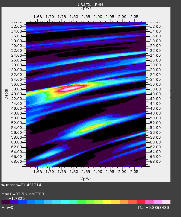
| Estimated Moho Depth: |
37.5 km |
| Estimated Crust Vp/Vs: |
1.78 |
| Assumed Crust Vp: |
6.419 km/s |
| Estimated Crust Vs: |
3.601 km/s |
| Estimated Crust Poisson's Ratio: |
0.27 |
|
| Radial Match: |
91.491714 % |
| Radial Bump: |
282 |
| Transverse Match: |
68.62703 % |
| Transverse Bump: |
400 |
| SOD ConfigId: |
110177 |
| Insert Time: |
2010-03-05 07:01:27.786 +0000 |
| GWidth: |
2.5 |
| Max Bumps: |
400 |
| Tol: |
0.001 |
|
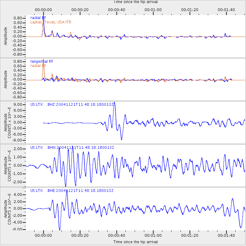
Signal To Noise
| Channel | StoN | STA | LTA |
| US:LTX: :BHN:20041121T11:48:18.180013Z | 1.6646686 | 3.0291235E-7 | 1.8196556E-7 |
| US:LTX: :BHE:20041121T11:48:18.180013Z | 2.7249134 | 6.343751E-7 | 2.328056E-7 |
| US:LTX: :BHZ:20041121T11:48:18.180013Z | 7.8967967 | 1.1081765E-6 | 1.4033242E-7 |
| Arrivals |
| Ps | 4.9 SECOND |
| PpPs | 15 SECOND |
| PsPs/PpSs | 20 SECOND |


