You are here: Home > Network List > UU - University of Utah Regional Network Stations List
> Station MTPU Mt. Pierson, UT, USA > Earthquake Result Viewer
MTPU Mt. Pierson, UT, USA - Earthquake Result Viewer
| Earthquake location: |
Nicaragua |
| Earthquake latitude/longitude: |
12.4/-86.6 |
| Earthquake time(UTC): |
2016/09/15 (259) 05:57:24 GMT |
| Earthquake Depth: |
10 km |
| Earthquake Magnitude: |
5.7 mww |
| Earthquake Catalog/Contributor: |
NEIC PDE/us |
|
| Network: |
UU University of Utah Regional Network |
| Station: |
MTPU Mt. Pierson, UT, USA |
| Lat/Lon: |
38.04 N/112.18 W |
| Elevation: |
3112 m |
|
| Distance: |
34.2 deg |
| Az: |
322.704 deg |
| Baz: |
131.441 deg |
| Ray Param: |
0.07786426 |
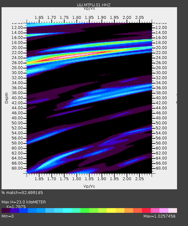
| Estimated Moho Depth: |
23.0 km |
| Estimated Crust Vp/Vs: |
1.79 |
| Assumed Crust Vp: |
6.276 km/s |
| Estimated Crust Vs: |
3.511 km/s |
| Estimated Crust Poisson's Ratio: |
0.27 |
|
| Radial Match: |
82.699165 % |
| Radial Bump: |
374 |
| Transverse Match: |
63.677677 % |
| Transverse Bump: |
400 |
| SOD ConfigId: |
11737051 |
| Insert Time: |
2019-04-25 13:01:56.993 +0000 |
| GWidth: |
2.5 |
| Max Bumps: |
400 |
| Tol: |
0.001 |
|

Signal To Noise
| Channel | StoN | STA | LTA |
| UU:MTPU:01:HHZ:20160915T06:03:38.97801Z | 3.3498871 | 9.3349986E-9 | 2.7866607E-9 |
| UU:MTPU:01:HHN:20160915T06:03:38.97801Z | 2.03304 | 7.663265E-9 | 3.769362E-9 |
| UU:MTPU:01:HHE:20160915T06:03:38.97801Z | 1.2193367 | 5.37331E-9 | 4.406748E-9 |
| Arrivals |
| Ps | 3.1 SECOND |
| PpPs | 9.5 SECOND |
| PsPs/PpSs | 13 SECOND |


