You are here: Home > Network List > US - United States National Seismic Network Stations List
> Station LTX Lajitas, Texas, USA > Earthquake Result Viewer
LTX Lajitas, Texas, USA - Earthquake Result Viewer
| Earthquake location: |
Kuril Islands |
| Earthquake latitude/longitude: |
47.0/153.4 |
| Earthquake time(UTC): |
2007/04/15 (105) 04:12:30 GMT |
| Earthquake Depth: |
35 km |
| Earthquake Magnitude: |
5.6 MB, 5.0 MS, 5.5 MW, 5.5 MW |
| Earthquake Catalog/Contributor: |
WHDF/NEIC |
|
| Network: |
US United States National Seismic Network |
| Station: |
LTX Lajitas, Texas, USA |
| Lat/Lon: |
29.33 N/103.67 W |
| Elevation: |
1013 m |
|
| Distance: |
77.2 deg |
| Az: |
60.8 deg |
| Baz: |
316.826 deg |
| Ray Param: |
0.050449576 |
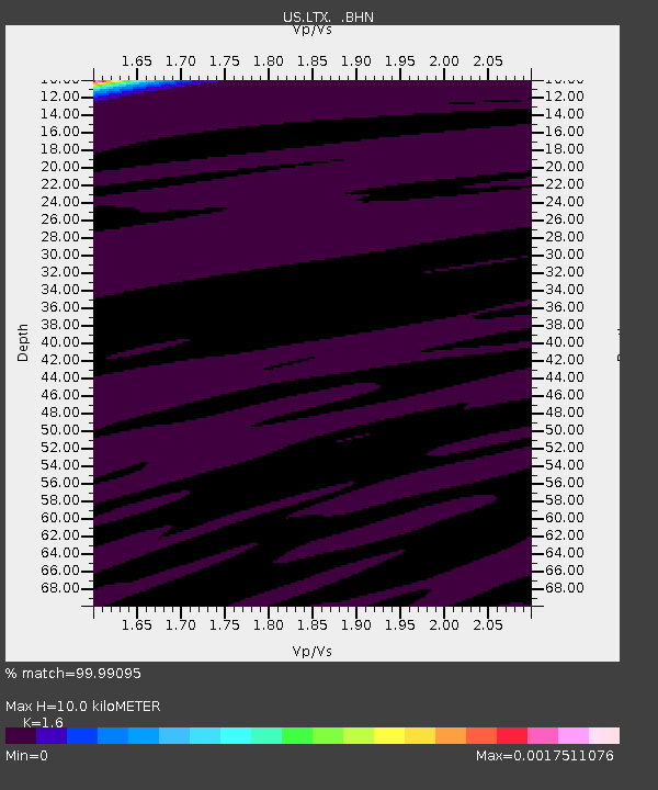
| Estimated Moho Depth: |
10.0 km |
| Estimated Crust Vp/Vs: |
1.60 |
| Assumed Crust Vp: |
6.419 km/s |
| Estimated Crust Vs: |
4.012 km/s |
| Estimated Crust Poisson's Ratio: |
0.18 |
|
| Radial Match: |
99.99095 % |
| Radial Bump: |
5 |
| Transverse Match: |
99.612816 % |
| Transverse Bump: |
70 |
| SOD ConfigId: |
2564 |
| Insert Time: |
2010-03-05 07:01:32.041 +0000 |
| GWidth: |
2.5 |
| Max Bumps: |
400 |
| Tol: |
0.001 |
|
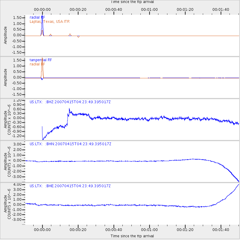
Signal To Noise
| Channel | StoN | STA | LTA |
| US:LTX: :BHN:20070415T04:23:49.395017Z | 1.1084316 | 2.7450943E-7 | 2.4765572E-7 |
| US:LTX: :BHE:20070415T04:23:49.395017Z | 0.6429692 | 3.5237136E-7 | 5.4803775E-7 |
| US:LTX: :BHZ:20070415T04:23:49.395017Z | 0.6120813 | 3.569144E-7 | 5.8311605E-7 |
| Arrivals |
| Ps | 1.0 SECOND |
| PpPs | 3.9 SECOND |
| PsPs/PpSs | 4.9 SECOND |


