You are here: Home > Network List > US - United States National Seismic Network Stations List
> Station LTX Lajitas, Texas, USA > Earthquake Result Viewer
LTX Lajitas, Texas, USA - Earthquake Result Viewer
| Earthquake location: |
Southeast Of Honshu, Japan |
| Earthquake latitude/longitude: |
30.9/141.7 |
| Earthquake time(UTC): |
2007/04/04 (094) 21:40:18 GMT |
| Earthquake Depth: |
9.0 km |
| Earthquake Magnitude: |
5.7 MW, 5.4 MS, 5.4 MB, 5.6 MW |
| Earthquake Catalog/Contributor: |
WHDF/NEIC |
|
| Network: |
US United States National Seismic Network |
| Station: |
LTX Lajitas, Texas, USA |
| Lat/Lon: |
29.33 N/103.67 W |
| Elevation: |
1013 m |
|
| Distance: |
93.7 deg |
| Az: |
52.671 deg |
| Baz: |
308.504 deg |
| Ray Param: |
0.04121738 |
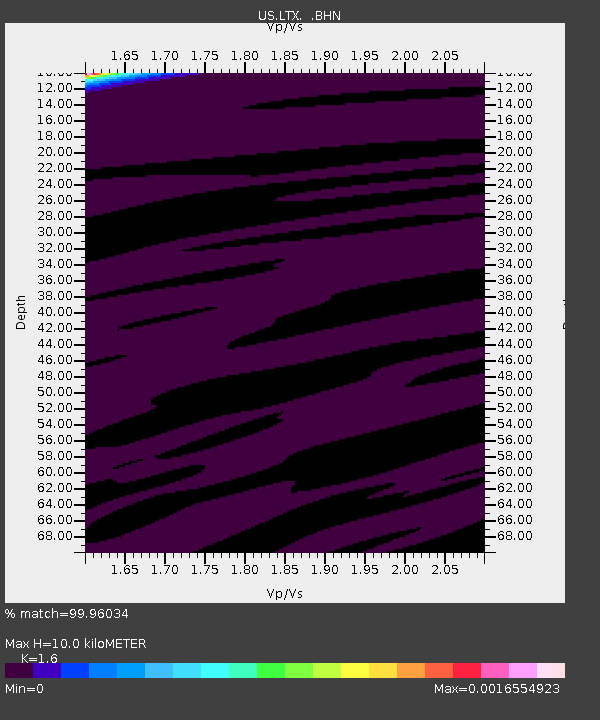
| Estimated Moho Depth: |
10.0 km |
| Estimated Crust Vp/Vs: |
1.60 |
| Assumed Crust Vp: |
6.419 km/s |
| Estimated Crust Vs: |
4.012 km/s |
| Estimated Crust Poisson's Ratio: |
0.18 |
|
| Radial Match: |
99.96034 % |
| Radial Bump: |
6 |
| Transverse Match: |
93.26596 % |
| Transverse Bump: |
129 |
| SOD ConfigId: |
2564 |
| Insert Time: |
2010-03-05 07:01:34.178 +0000 |
| GWidth: |
2.5 |
| Max Bumps: |
400 |
| Tol: |
0.001 |
|
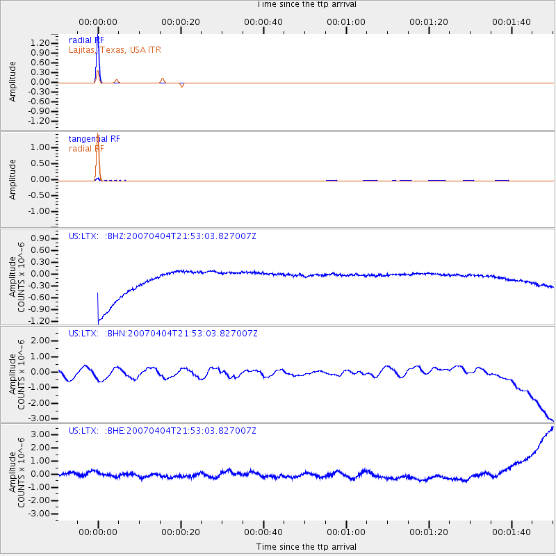
Signal To Noise
| Channel | StoN | STA | LTA |
| US:LTX: :BHN:20070404T21:53:03.827007Z | 1.3093626 | 4.6030203E-7 | 3.5154662E-7 |
| US:LTX: :BHE:20070404T21:53:03.827007Z | 0.91317964 | 2.9567894E-7 | 3.2379057E-7 |
| US:LTX: :BHZ:20070404T21:53:03.827007Z | 0.8642489 | 3.2705717E-7 | 3.784294E-7 |
| Arrivals |
| Ps | 1.0 SECOND |
| PpPs | 4.0 SECOND |
| PsPs/PpSs | 4.9 SECOND |


