You are here: Home > Network List > US - United States National Seismic Network Stations List
> Station LTX Lajitas, Texas, USA > Earthquake Result Viewer
LTX Lajitas, Texas, USA - Earthquake Result Viewer
| Earthquake location: |
Southeast Of Loyalty Islands |
| Earthquake latitude/longitude: |
-22.0/170.6 |
| Earthquake time(UTC): |
2005/04/11 (101) 17:08:53 GMT |
| Earthquake Depth: |
68 km |
| Earthquake Magnitude: |
6.0 MB, 6.8 MW, 6.8 MW |
| Earthquake Catalog/Contributor: |
WHDF/NEIC |
|
| Network: |
US United States National Seismic Network |
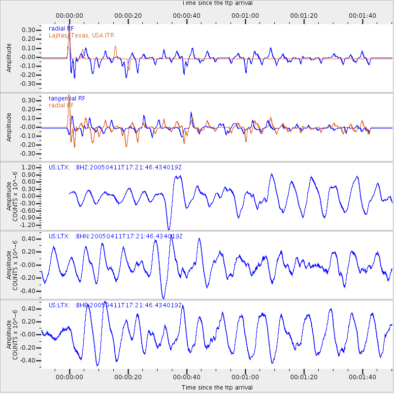
| Station: |
LTX Lajitas, Texas, USA |
| Lat/Lon: |
29.33 N/103.67 W |
| Elevation: |
1013 m |
|
| Distance: |
96.9 deg |
| Az: |
61.303 deg |
| Baz: |
248.822 deg |
| Ray Param: |
0.040314965 |
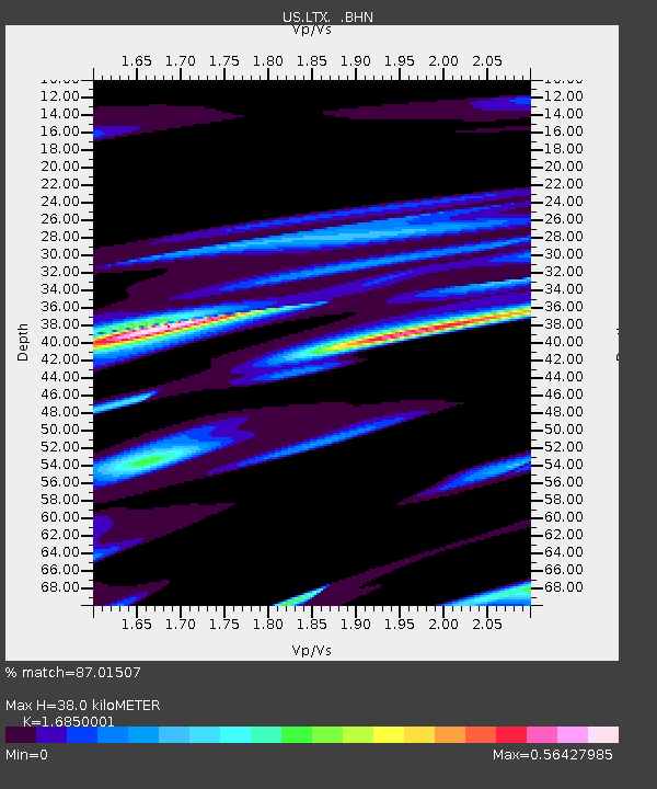
| Estimated Moho Depth: |
38.0 km |
| Estimated Crust Vp/Vs: |
1.69 |
| Assumed Crust Vp: |
6.419 km/s |
| Estimated Crust Vs: |
3.81 km/s |
| Estimated Crust Poisson's Ratio: |
0.23 |
|
| Radial Match: |
87.01507 % |
| Radial Bump: |
400 |
| Transverse Match: |
70.944725 % |
| Transverse Bump: |
346 |
| SOD ConfigId: |
2459 |
| Insert Time: |
2010-03-05 07:01:35.574 +0000 |
| GWidth: |
2.5 |
| Max Bumps: |
400 |
| Tol: |
0.001 |
|
Signal To Noise
| Channel | StoN | STA | LTA |
| US:LTX: :BHN:20050411T17:21:46.434019Z | 0.96526355 | 1.2741918E-7 | 1.3200454E-7 |
| US:LTX: :BHE:20050411T17:21:46.434019Z | 2.0222275 | 2.1302866E-7 | 1.0534357E-7 |
| US:LTX: :BHZ:20050411T17:21:46.434019Z | 3.2409163 | 6.2750274E-7 | 1.9361893E-7 |
| Arrivals |
| Ps | 4.1 SECOND |
| PpPs | 16 SECOND |
| PsPs/PpSs | 20 SECOND |


