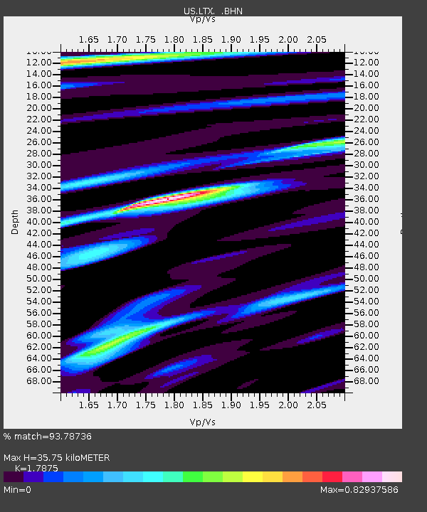
LTX Lajitas, Texas, USA - Earthquake Result Viewer
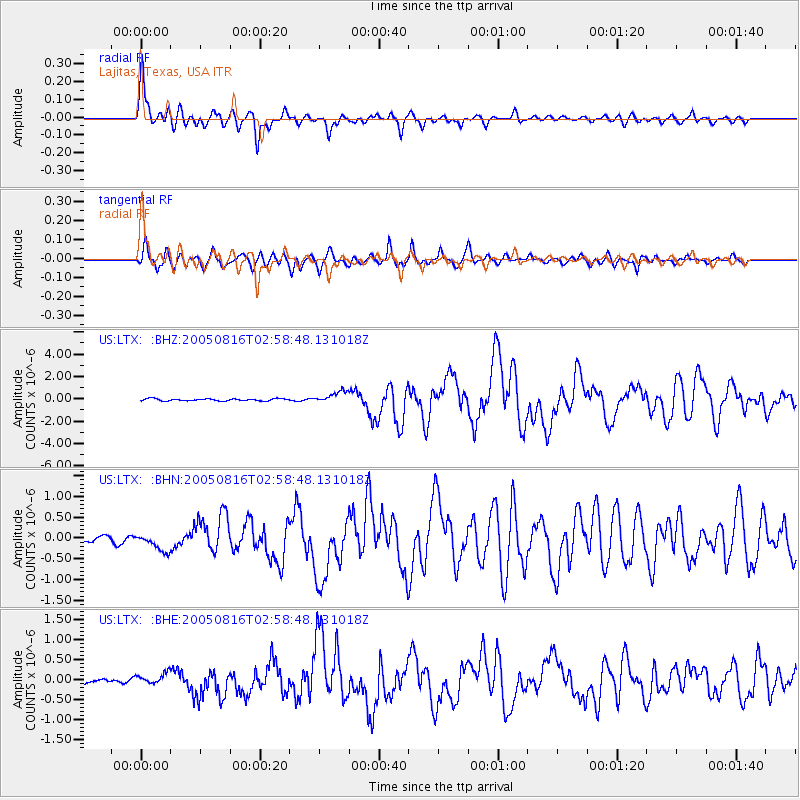
Earthquake location: Near East Coast Of Honshu, Japan
Earthquake latitude/longitude: 38.3/142.0
Earthquake time(UTC): 2005/08/16 (228) 02:46:28 GMT
Earthquake Depth: 36 km
Earthquake Magnitude: 6.5 MB, 6.8 MS, 7.2 MW, 7.1 MW
Earthquake Catalog/Contributor: WHDF/NEIC
Network: US United States National Seismic Network
Station: LTX Lajitas, Texas, USA
Lat/Lon: 29.33 N/103.67 W
Elevation: 1013 m
Distance: 89.0 deg
Az: 52.748 deg
Baz: 314.154 deg
Ray Param: 0.04214191
Estimated Moho Depth: 35.75 km
Estimated Crust Vp/Vs: 1.79
Assumed Crust Vp: 6.419 km/s
Estimated Crust Vs: 3.591 km/s
Estimated Crust Poisson's Ratio: 0.27
Radial Match: 93.78736 %
Radial Bump: 400
Transverse Match: 90.18589 %
Transverse Bump: 400
SOD ConfigId: 110165
Insert Time: 2010-03-05 07:01:40.264 +0000
GWidth: 2.5
Max Bumps: 400
Tol: 0.001

Signal To Noise

ChannelStoNSTALTA
US:LTX: :BHN:20050816T02:58:48.131018Z1.65211952.0340403E-71.2311702E-7
US:LTX: :BHE:20050816T02:58:48.131018Z1.66285941.3892115E-78.3543526E-8
US:LTX: :BHZ:20050816T02:58:48.131018Z5.66037035.25441E-79.282803E-8
Arrivals
Ps4.5 SECOND
PpPs15 SECOND
PsPs/PpSs20 SECOND