You are here: Home > Network List > US - United States National Seismic Network Stations List
> Station LTX Lajitas, Texas, USA > Earthquake Result Viewer
LTX Lajitas, Texas, USA - Earthquake Result Viewer
| Earthquake location: |
Queen Charlotte Islands Region |
| Earthquake latitude/longitude: |
51.6/-131.1 |
| Earthquake time(UTC): |
2005/06/09 (160) 14:00:49 GMT |
| Earthquake Depth: |
10 km |
| Earthquake Magnitude: |
5.2 MB, 5.5 MS, 5.8 MW, 5.8 MW |
| Earthquake Catalog/Contributor: |
WHDF/NEIC |
|
| Network: |
US United States National Seismic Network |
| Station: |
LTX Lajitas, Texas, USA |
| Lat/Lon: |
29.33 N/103.67 W |
| Elevation: |
1013 m |
|
| Distance: |
30.2 deg |
| Az: |
126.777 deg |
| Baz: |
325.061 deg |
| Ray Param: |
0.07940073 |
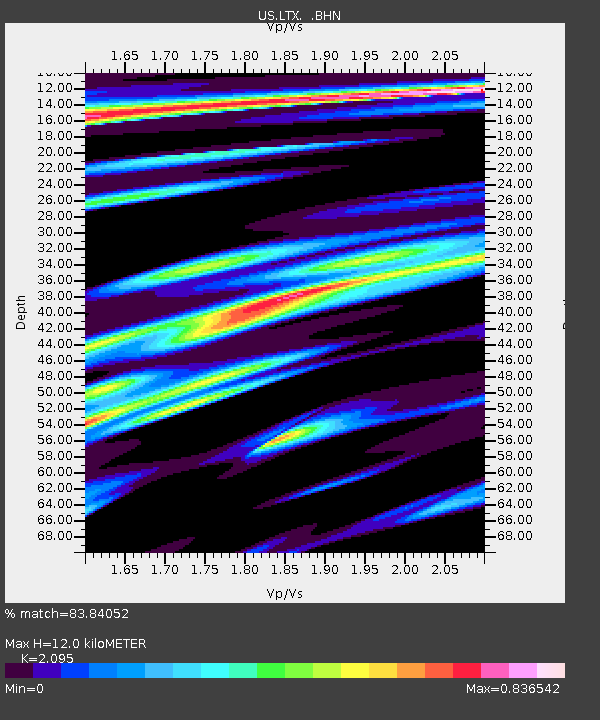
| Estimated Moho Depth: |
12.0 km |
| Estimated Crust Vp/Vs: |
2.10 |
| Assumed Crust Vp: |
6.419 km/s |
| Estimated Crust Vs: |
3.064 km/s |
| Estimated Crust Poisson's Ratio: |
0.35 |
|
| Radial Match: |
83.84052 % |
| Radial Bump: |
331 |
| Transverse Match: |
63.90016 % |
| Transverse Bump: |
400 |
| SOD ConfigId: |
110165 |
| Insert Time: |
2010-03-05 07:01:43.041 +0000 |
| GWidth: |
2.5 |
| Max Bumps: |
400 |
| Tol: |
0.001 |
|
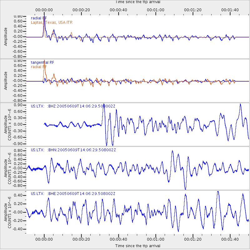
Signal To Noise
| Channel | StoN | STA | LTA |
| US:LTX: :BHN:20050609T14:06:29.508002Z | 4.3531322 | 3.2482404E-7 | 7.461846E-8 |
| US:LTX: :BHE:20050609T14:06:29.508002Z | 3.1842113 | 1.6671981E-7 | 5.235828E-8 |
| US:LTX: :BHZ:20050609T14:06:29.508002Z | 7.733188 | 5.2153683E-7 | 6.744137E-8 |
| Arrivals |
| Ps | 2.2 SECOND |
| PpPs | 5.4 SECOND |
| PsPs/PpSs | 7.6 SECOND |


