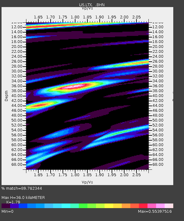
LTX Lajitas, Texas, USA - Earthquake Result Viewer
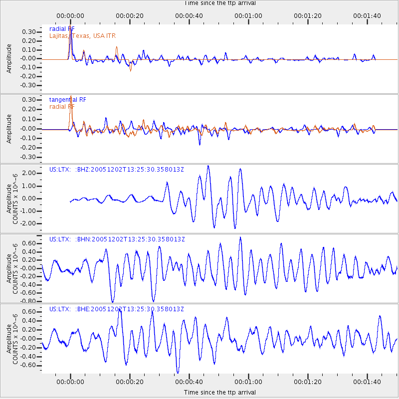
Earthquake location: Near East Coast Of Honshu, Japan
Earthquake latitude/longitude: 38.1/142.1
Earthquake time(UTC): 2005/12/02 (336) 13:13:09 GMT
Earthquake Depth: 29 km
Earthquake Magnitude: 6.1 MB, 6.3 MS, 6.5 MW, 6.4 MW
Earthquake Catalog/Contributor: WHDF/NEIC
Network: US United States National Seismic Network
Station: LTX Lajitas, Texas, USA
Lat/Lon: 29.33 N/103.67 W
Elevation: 1013 m
Distance: 89.0 deg
Az: 52.796 deg
Baz: 313.966 deg
Ray Param: 0.042111266
Estimated Moho Depth: 36.0 km
Estimated Crust Vp/Vs: 1.79
Assumed Crust Vp: 6.419 km/s
Estimated Crust Vs: 3.586 km/s
Estimated Crust Poisson's Ratio: 0.27
Radial Match: 89.762344 %
Radial Bump: 400
Transverse Match: 75.795746 %
Transverse Bump: 360
SOD ConfigId: 2422
Insert Time: 2010-03-05 07:01:47.396 +0000
GWidth: 2.5
Max Bumps: 400
Tol: 0.001

Signal To Noise

ChannelStoNSTALTA
US:LTX: :BHN:20051202T13:25:30.358013Z0.75907878.901082E-81.1726165E-7
US:LTX: :BHE:20051202T13:25:30.358013Z0.97841381.5393694E-71.5733316E-7
US:LTX: :BHZ:20051202T13:25:30.358013Z4.0879076.55207E-71.6027933E-7
Arrivals
Ps4.5 SECOND
PpPs15 SECOND
PsPs/PpSs20 SECOND