You are here: Home > Network List > US - United States National Seismic Network Stations List
> Station LTX Lajitas, Texas, USA > Earthquake Result Viewer
LTX Lajitas, Texas, USA - Earthquake Result Viewer
| Earthquake location: |
West Chile Rise |
| Earthquake latitude/longitude: |
-36.3/-97.3 |
| Earthquake time(UTC): |
2005/07/10 (191) 04:46:31 GMT |
| Earthquake Depth: |
10 km |
| Earthquake Magnitude: |
5.3 MB, 5.7 MS, 6.1 MW, 6.0 MW |
| Earthquake Catalog/Contributor: |
WHDF/NEIC |
|
| Network: |
US United States National Seismic Network |
| Station: |
LTX Lajitas, Texas, USA |
| Lat/Lon: |
29.33 N/103.67 W |
| Elevation: |
1013 m |
|
| Distance: |
65.6 deg |
| Az: |
353.861 deg |
| Baz: |
174.322 deg |
| Ray Param: |
0.05818287 |
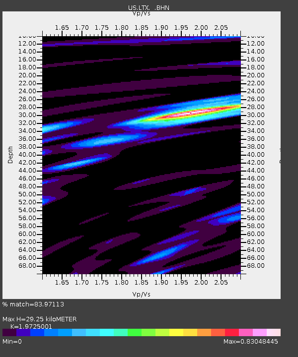
| Estimated Moho Depth: |
29.25 km |
| Estimated Crust Vp/Vs: |
1.97 |
| Assumed Crust Vp: |
6.419 km/s |
| Estimated Crust Vs: |
3.254 km/s |
| Estimated Crust Poisson's Ratio: |
0.33 |
|
| Radial Match: |
83.97113 % |
| Radial Bump: |
400 |
| Transverse Match: |
53.773846 % |
| Transverse Bump: |
400 |
| SOD ConfigId: |
2475 |
| Insert Time: |
2010-03-05 07:01:53.313 +0000 |
| GWidth: |
2.5 |
| Max Bumps: |
400 |
| Tol: |
0.001 |
|
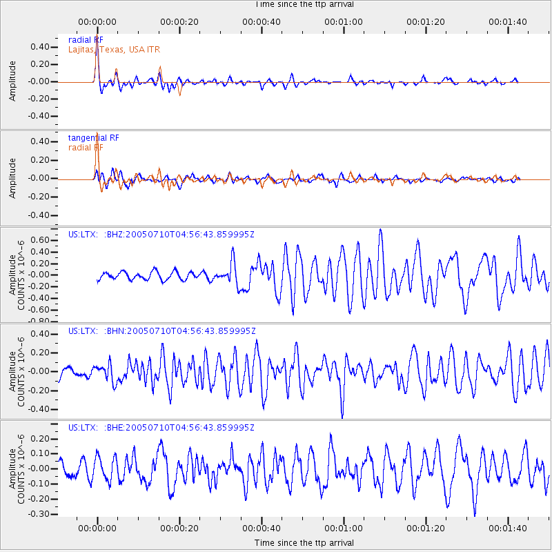
Signal To Noise
| Channel | StoN | STA | LTA |
| US:LTX: :BHN:20050710T04:56:43.859995Z | 1.5713543 | 9.3140905E-8 | 5.927429E-8 |
| US:LTX: :BHE:20050710T04:56:43.859995Z | 1.4933205 | 7.6602845E-8 | 5.1296993E-8 |
| US:LTX: :BHZ:20050710T04:56:43.859995Z | 2.9757535 | 1.958919E-7 | 6.582934E-8 |
| Arrivals |
| Ps | 4.6 SECOND |
| PpPs | 13 SECOND |
| PsPs/PpSs | 18 SECOND |


