You are here: Home > Network List > US - United States National Seismic Network Stations List
> Station LTX Lajitas, Texas, USA > Earthquake Result Viewer
LTX Lajitas, Texas, USA - Earthquake Result Viewer
| Earthquake location: |
Fiji Islands Region |
| Earthquake latitude/longitude: |
-14.4/-177.3 |
| Earthquake time(UTC): |
2005/08/07 (219) 11:35:26 GMT |
| Earthquake Depth: |
10 km |
| Earthquake Magnitude: |
5.7 MB, 5.9 MS, 6.0 MW, 6.0 MW |
| Earthquake Catalog/Contributor: |
WHDF/NEIC |
|
| Network: |
US United States National Seismic Network |
| Station: |
LTX Lajitas, Texas, USA |
| Lat/Lon: |
29.33 N/103.67 W |
| Elevation: |
1013 m |
|
| Distance: |
83.2 deg |
| Az: |
57.524 deg |
| Baz: |
249.387 deg |
| Ray Param: |
0.046325617 |
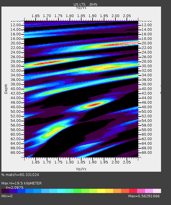
| Estimated Moho Depth: |
19.5 km |
| Estimated Crust Vp/Vs: |
2.10 |
| Assumed Crust Vp: |
6.419 km/s |
| Estimated Crust Vs: |
3.06 km/s |
| Estimated Crust Poisson's Ratio: |
0.35 |
|
| Radial Match: |
90.331024 % |
| Radial Bump: |
344 |
| Transverse Match: |
75.914604 % |
| Transverse Bump: |
400 |
| SOD ConfigId: |
2475 |
| Insert Time: |
2010-03-05 07:01:56.384 +0000 |
| GWidth: |
2.5 |
| Max Bumps: |
400 |
| Tol: |
0.001 |
|
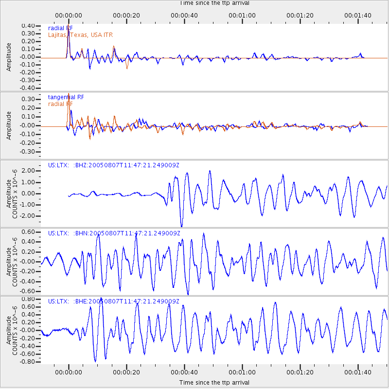
Signal To Noise
| Channel | StoN | STA | LTA |
| US:LTX: :BHN:20050807T11:47:21.249009Z | 1.4596629 | 1.2823284E-7 | 8.785099E-8 |
| US:LTX: :BHE:20050807T11:47:21.249009Z | 0.9240276 | 8.632769E-8 | 9.3425434E-8 |
| US:LTX: :BHZ:20050807T11:47:21.249009Z | 4.10641 | 4.1423925E-7 | 1.0087625E-7 |
| Arrivals |
| Ps | 3.4 SECOND |
| PpPs | 9.2 SECOND |
| PsPs/PpSs | 13 SECOND |


