You are here: Home > Network List > US - United States National Seismic Network Stations List
> Station LTX Lajitas, Texas, USA > Earthquake Result Viewer
LTX Lajitas, Texas, USA - Earthquake Result Viewer
| Earthquake location: |
Easter Island Region |
| Earthquake latitude/longitude: |
-26.6/-114.5 |
| Earthquake time(UTC): |
2005/08/04 (216) 10:27:12 GMT |
| Earthquake Depth: |
10 km |
| Earthquake Magnitude: |
5.9 MB, 5.4 MS, 5.8 MW, 5.8 MW |
| Earthquake Catalog/Contributor: |
WHDF/NEIC |
|
| Network: |
US United States National Seismic Network |
| Station: |
LTX Lajitas, Texas, USA |
| Lat/Lon: |
29.33 N/103.67 W |
| Elevation: |
1013 m |
|
| Distance: |
56.6 deg |
| Az: |
11.34 deg |
| Baz: |
191.628 deg |
| Ray Param: |
0.064028546 |
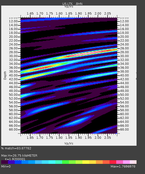
| Estimated Moho Depth: |
28.75 km |
| Estimated Crust Vp/Vs: |
1.92 |
| Assumed Crust Vp: |
6.419 km/s |
| Estimated Crust Vs: |
3.343 km/s |
| Estimated Crust Poisson's Ratio: |
0.31 |
|
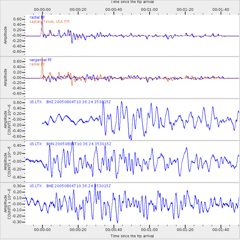
| Radial Match: |
83.87782 % |
| Radial Bump: |
400 |
| Transverse Match: |
61.31969 % |
| Transverse Bump: |
400 |
| SOD ConfigId: |
2500 |
| Insert Time: |
2010-03-05 07:02:00.577 +0000 |
| GWidth: |
2.5 |
| Max Bumps: |
400 |
| Tol: |
0.001 |
|
Signal To Noise
| Channel | StoN | STA | LTA |
| US:LTX: :BHN:20050804T10:36:24.353015Z | 3.2458868 | 1.6049519E-7 | 4.9445713E-8 |
| US:LTX: :BHE:20050804T10:36:24.353015Z | 1.2151378 | 7.7123E-8 | 6.346852E-8 |
| US:LTX: :BHZ:20050804T10:36:24.353015Z | 2.4448092 | 2.3529473E-7 | 9.624258E-8 |
| Arrivals |
| Ps | 4.3 SECOND |
| PpPs | 12 SECOND |
| PsPs/PpSs | 17 SECOND |


