You are here: Home > Network List > US - United States National Seismic Network Stations List
> Station LTX Lajitas, Texas, USA > Earthquake Result Viewer
LTX Lajitas, Texas, USA - Earthquake Result Viewer
| Earthquake location: |
Kermadec Islands, New Zealand |
| Earthquake latitude/longitude: |
-30.4/-177.8 |
| Earthquake time(UTC): |
1999/08/01 (213) 08:39:04 GMT |
| Earthquake Depth: |
10 km |
| Earthquake Magnitude: |
5.7 MB, 6.4 MS, 6.6 MW, 6.0 ME |
| Earthquake Catalog/Contributor: |
WHDF/NEIC |
|
| Network: |
US United States National Seismic Network |
| Station: |
LTX Lajitas, Texas, USA |
| Lat/Lon: |
29.33 N/103.67 W |
| Elevation: |
1013 m |
|
| Distance: |
92.2 deg |
| Az: |
57.213 deg |
| Baz: |
236.317 deg |
| Ray Param: |
0.041486807 |
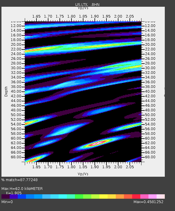
| Estimated Moho Depth: |
62.0 km |
| Estimated Crust Vp/Vs: |
1.90 |
| Assumed Crust Vp: |
6.419 km/s |
| Estimated Crust Vs: |
3.37 km/s |
| Estimated Crust Poisson's Ratio: |
0.31 |
|
| Radial Match: |
87.77248 % |
| Radial Bump: |
400 |
| Transverse Match: |
83.780815 % |
| Transverse Bump: |
400 |
| SOD ConfigId: |
110177 |
| Insert Time: |
2010-03-05 07:02:04.467 +0000 |
| GWidth: |
2.5 |
| Max Bumps: |
400 |
| Tol: |
0.001 |
|
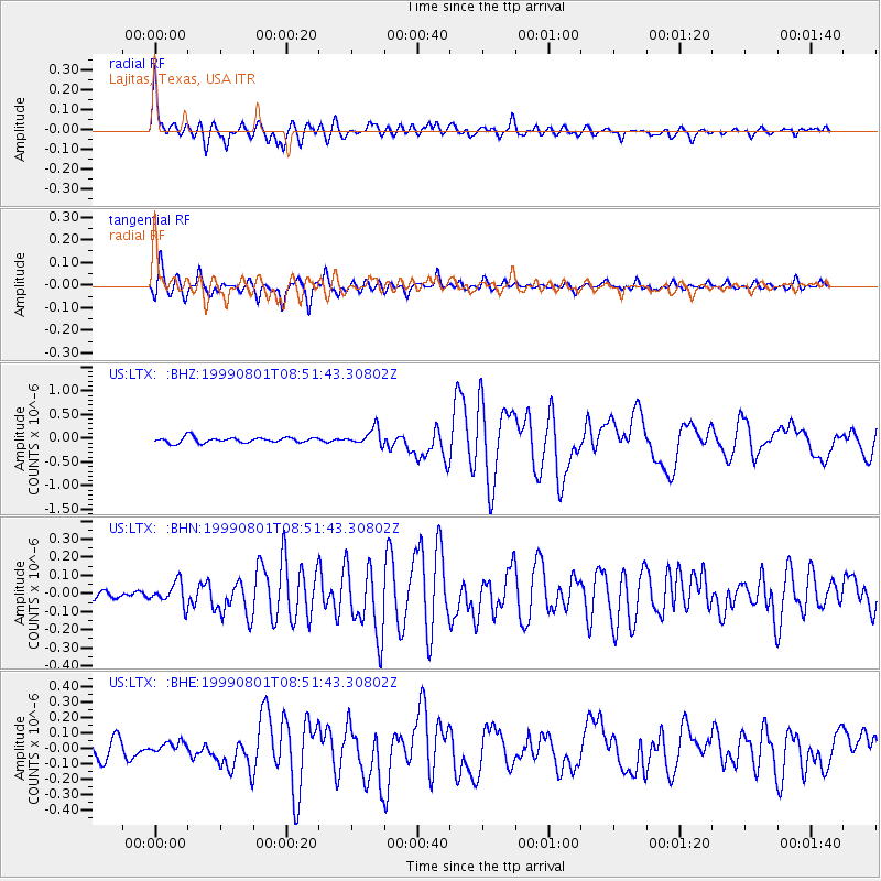
Signal To Noise
| Channel | StoN | STA | LTA |
| US:LTX: :BHN:19990801T08:51:43.30802Z | 1.9210813 | 6.155326E-8 | 3.2040944E-8 |
| US:LTX: :BHE:19990801T08:51:43.30802Z | 0.4513198 | 3.500073E-8 | 7.7551945E-8 |
| US:LTX: :BHZ:19990801T08:51:43.30802Z | 3.0261724 | 1.7486438E-7 | 5.7784014E-8 |
| Arrivals |
| Ps | 8.9 SECOND |
| PpPs | 28 SECOND |
| PsPs/PpSs | 36 SECOND |


