You are here: Home > Network List > US - United States National Seismic Network Stations List
> Station LTX Lajitas, Texas, USA > Earthquake Result Viewer
LTX Lajitas, Texas, USA - Earthquake Result Viewer
| Earthquake location: |
Off Coast Of Southern Chile |
| Earthquake latitude/longitude: |
-40.5/-74.8 |
| Earthquake time(UTC): |
1999/08/22 (234) 09:35:39 GMT |
| Earthquake Depth: |
33 km |
| Earthquake Magnitude: |
6.2 MB, 5.8 MS, 6.4 MW, 6.2 MW |
| Earthquake Catalog/Contributor: |
WHDF/NEIC |
|
| Network: |
US United States National Seismic Network |
| Station: |
LTX Lajitas, Texas, USA |
| Lat/Lon: |
29.33 N/103.67 W |
| Elevation: |
1013 m |
|
| Distance: |
74.5 deg |
| Az: |
334.018 deg |
| Baz: |
157.509 deg |
| Ray Param: |
0.05225103 |
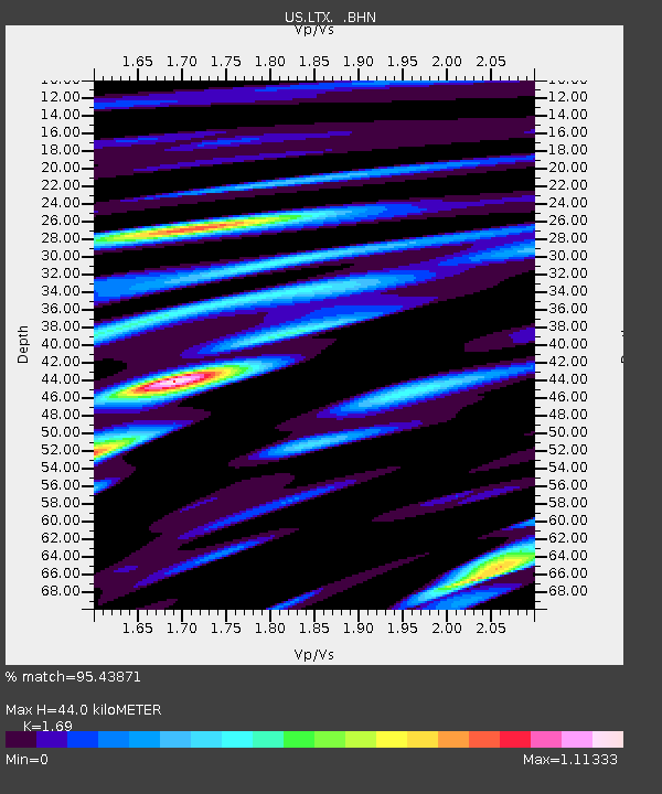
| Estimated Moho Depth: |
44.0 km |
| Estimated Crust Vp/Vs: |
1.69 |
| Assumed Crust Vp: |
6.419 km/s |
| Estimated Crust Vs: |
3.798 km/s |
| Estimated Crust Poisson's Ratio: |
0.23 |
|
| Radial Match: |
95.43871 % |
| Radial Bump: |
400 |
| Transverse Match: |
85.81231 % |
| Transverse Bump: |
400 |
| SOD ConfigId: |
110177 |
| Insert Time: |
2010-03-05 07:02:08.071 +0000 |
| GWidth: |
2.5 |
| Max Bumps: |
400 |
| Tol: |
0.001 |
|
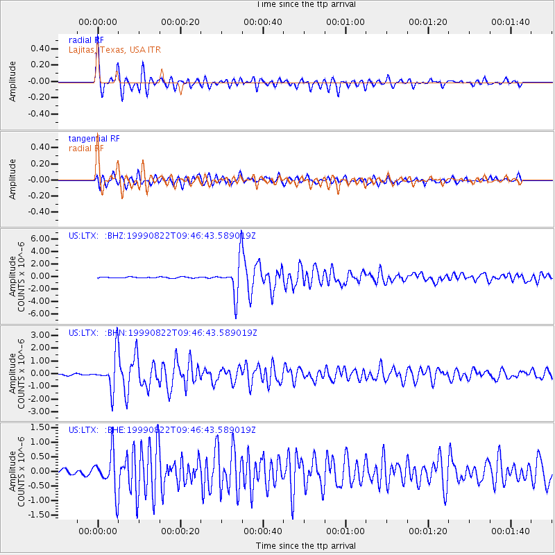
Signal To Noise
| Channel | StoN | STA | LTA |
| US:LTX: :BHN:19990822T09:46:43.589019Z | 15.601789 | 1.4235651E-6 | 9.1243706E-8 |
| US:LTX: :BHE:19990822T09:46:43.589019Z | 8.216398 | 6.7717997E-7 | 8.2418104E-8 |
| US:LTX: :BHZ:19990822T09:46:43.589019Z | 33.770607 | 3.006978E-6 | 8.904127E-8 |
| Arrivals |
| Ps | 4.9 SECOND |
| PpPs | 18 SECOND |
| PsPs/PpSs | 23 SECOND |


