You are here: Home > Network List > US - United States National Seismic Network Stations List
> Station LTX Lajitas, Texas, USA > Earthquake Result Viewer
LTX Lajitas, Texas, USA - Earthquake Result Viewer
| Earthquake location: |
Ecuador |
| Earthquake latitude/longitude: |
-1.3/-77.5 |
| Earthquake time(UTC): |
1999/08/28 (240) 12:40:06 GMT |
| Earthquake Depth: |
196 km |
| Earthquake Magnitude: |
5.9 MB, 6.3 MW, 6.2 MW |
| Earthquake Catalog/Contributor: |
WHDF/NEIC |
|
| Network: |
US United States National Seismic Network |
| Station: |
LTX Lajitas, Texas, USA |
| Lat/Lon: |
29.33 N/103.67 W |
| Elevation: |
1013 m |
|
| Distance: |
39.4 deg |
| Az: |
322.71 deg |
| Baz: |
136.079 deg |
| Ray Param: |
0.074279994 |
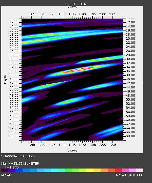
| Estimated Moho Depth: |
35.25 km |
| Estimated Crust Vp/Vs: |
1.88 |
| Assumed Crust Vp: |
6.419 km/s |
| Estimated Crust Vs: |
3.424 km/s |
| Estimated Crust Poisson's Ratio: |
0.30 |
|
| Radial Match: |
85.438126 % |
| Radial Bump: |
400 |
| Transverse Match: |
75.374825 % |
| Transverse Bump: |
400 |
| SOD ConfigId: |
110177 |
| Insert Time: |
2010-03-05 07:02:09.346 +0000 |
| GWidth: |
2.5 |
| Max Bumps: |
400 |
| Tol: |
0.001 |
|
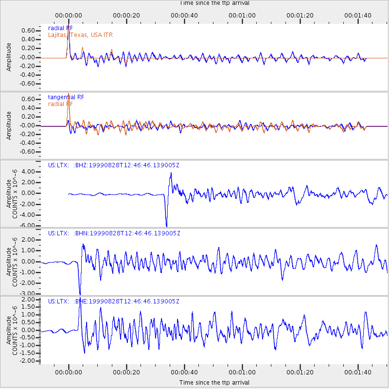
Signal To Noise
| Channel | StoN | STA | LTA |
| US:LTX: :BHN:19990828T12:46:46.139005Z | 10.853856 | 9.764138E-7 | 8.996009E-8 |
| US:LTX: :BHE:19990828T12:46:46.139005Z | 9.216263 | 6.8008296E-7 | 7.379162E-8 |
| US:LTX: :BHZ:19990828T12:46:46.139005Z | 18.938116 | 1.8834927E-6 | 9.945512E-8 |
| Arrivals |
| Ps | 5.1 SECOND |
| PpPs | 15 SECOND |
| PsPs/PpSs | 20 SECOND |


