You are here: Home > Network List > US - United States National Seismic Network Stations List
> Station LTX Lajitas, Texas, USA > Earthquake Result Viewer
LTX Lajitas, Texas, USA - Earthquake Result Viewer
| Earthquake location: |
Fiji Islands Region |
| Earthquake latitude/longitude: |
-17.5/-178.7 |
| Earthquake time(UTC): |
2006/06/09 (160) 05:58:27 GMT |
| Earthquake Depth: |
564 km |
| Earthquake Magnitude: |
5.3 MB, 6.1 MW, 6.1 MW |
| Earthquake Catalog/Contributor: |
WHDF/NEIC |
|
| Network: |
US United States National Seismic Network |
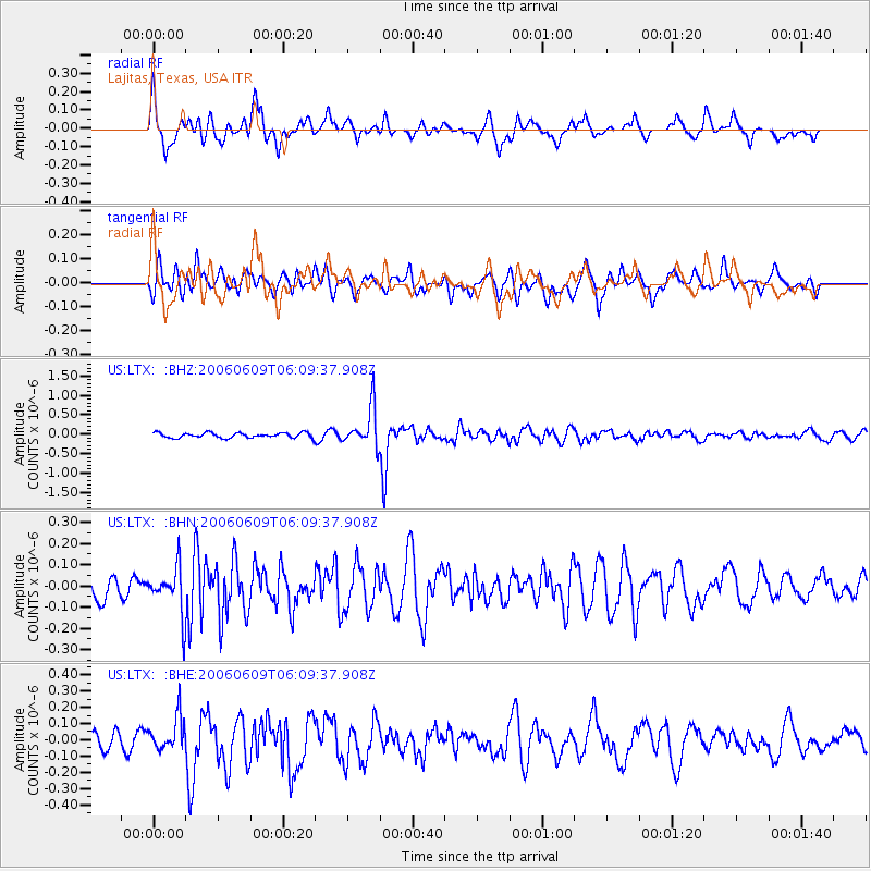
| Station: |
LTX Lajitas, Texas, USA |
| Lat/Lon: |
29.33 N/103.67 W |
| Elevation: |
1013 m |
|
| Distance: |
86.1 deg |
| Az: |
57.751 deg |
| Baz: |
247.539 deg |
| Ray Param: |
0.04270234 |
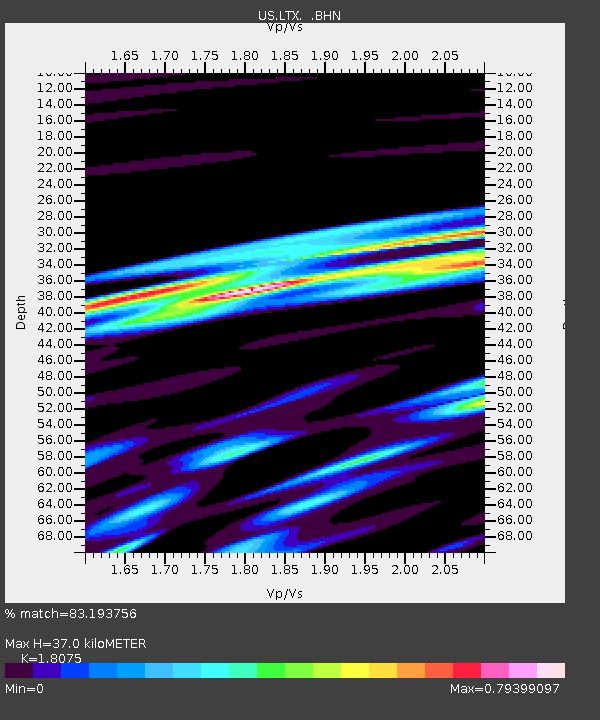
| Estimated Moho Depth: |
37.0 km |
| Estimated Crust Vp/Vs: |
1.81 |
| Assumed Crust Vp: |
6.419 km/s |
| Estimated Crust Vs: |
3.551 km/s |
| Estimated Crust Poisson's Ratio: |
0.28 |
|
| Radial Match: |
83.193756 % |
| Radial Bump: |
400 |
| Transverse Match: |
65.31351 % |
| Transverse Bump: |
400 |
| SOD ConfigId: |
2669 |
| Insert Time: |
2010-03-05 07:02:20.315 +0000 |
| GWidth: |
2.5 |
| Max Bumps: |
400 |
| Tol: |
0.001 |
|
Signal To Noise
| Channel | StoN | STA | LTA |
| US:LTX: :BHN:20060609T06:09:37.908Z | 2.0813053 | 1.07518275E-7 | 5.165906E-8 |
| US:LTX: :BHE:20060609T06:09:37.908Z | 1.85592 | 1.0497144E-7 | 5.6560328E-8 |
| US:LTX: :BHZ:20060609T06:09:37.908Z | 7.6902966 | 5.005757E-7 | 6.5091854E-8 |
| Arrivals |
| Ps | 4.8 SECOND |
| PpPs | 16 SECOND |
| PsPs/PpSs | 21 SECOND |


