You are here: Home > Network List > US - United States National Seismic Network Stations List
> Station LTX Lajitas, Texas, USA > Earthquake Result Viewer
LTX Lajitas, Texas, USA - Earthquake Result Viewer
| Earthquake location: |
Central Mid-Atlantic Ridge |
| Earthquake latitude/longitude: |
1.0/-28.2 |
| Earthquake time(UTC): |
2006/06/05 (156) 06:34:31 GMT |
| Earthquake Depth: |
10 km |
| Earthquake Magnitude: |
5.3 MB, 5.6 MW |
| Earthquake Catalog/Contributor: |
WHDF/NEIC |
|
| Network: |
US United States National Seismic Network |
| Station: |
LTX Lajitas, Texas, USA |
| Lat/Lon: |
29.33 N/103.67 W |
| Elevation: |
1013 m |
|
| Distance: |
76.9 deg |
| Az: |
299.765 deg |
| Baz: |
96.282 deg |
| Ray Param: |
0.05070249 |
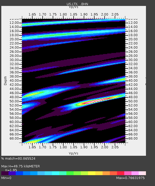
| Estimated Moho Depth: |
49.75 km |
| Estimated Crust Vp/Vs: |
1.95 |
| Assumed Crust Vp: |
6.419 km/s |
| Estimated Crust Vs: |
3.292 km/s |
| Estimated Crust Poisson's Ratio: |
0.32 |
|
| Radial Match: |
80.865524 % |
| Radial Bump: |
400 |
| Transverse Match: |
78.10574 % |
| Transverse Bump: |
400 |
| SOD ConfigId: |
2669 |
| Insert Time: |
2010-03-05 07:02:22.611 +0000 |
| GWidth: |
2.5 |
| Max Bumps: |
400 |
| Tol: |
0.001 |
|
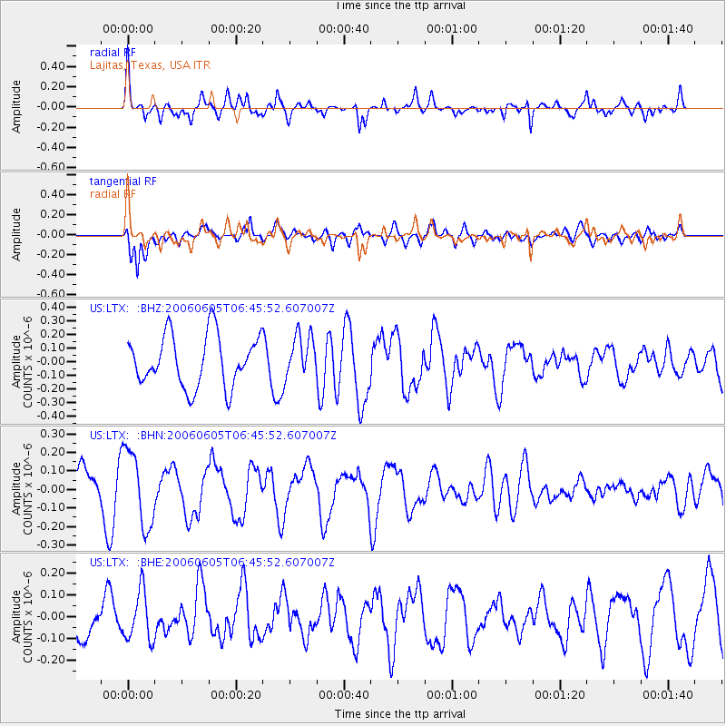
Signal To Noise
| Channel | StoN | STA | LTA |
| US:LTX: :BHN:20060605T06:45:52.607007Z | 1.4504219 | 2.0368506E-7 | 1.404316E-7 |
| US:LTX: :BHE:20060605T06:45:52.607007Z | 1.1294531 | 1.14866516E-7 | 1.0170101E-7 |
| US:LTX: :BHZ:20060605T06:45:52.607007Z | 0.81591016 | 1.5401884E-7 | 1.8876936E-7 |
| Arrivals |
| Ps | 7.6 SECOND |
| PpPs | 22 SECOND |
| PsPs/PpSs | 30 SECOND |


