You are here: Home > Network List > US - United States National Seismic Network Stations List
> Station LTX Lajitas, Texas, USA > Earthquake Result Viewer
LTX Lajitas, Texas, USA - Earthquake Result Viewer
| Earthquake location: |
Near Coast Of Northern Chile |
| Earthquake latitude/longitude: |
-27.2/-71.1 |
| Earthquake time(UTC): |
2006/04/30 (120) 21:40:58 GMT |
| Earthquake Depth: |
12 km |
| Earthquake Magnitude: |
5.9 MB, 6.7 MS, 6.5 MW, 6.3 ML |
| Earthquake Catalog/Contributor: |
WHDF/NEIC |
|
| Network: |
US United States National Seismic Network |
| Station: |
LTX Lajitas, Texas, USA |
| Lat/Lon: |
29.33 N/103.67 W |
| Elevation: |
1013 m |
|
| Distance: |
64.3 deg |
| Az: |
328.523 deg |
| Baz: |
147.822 deg |
| Ray Param: |
0.05899327 |
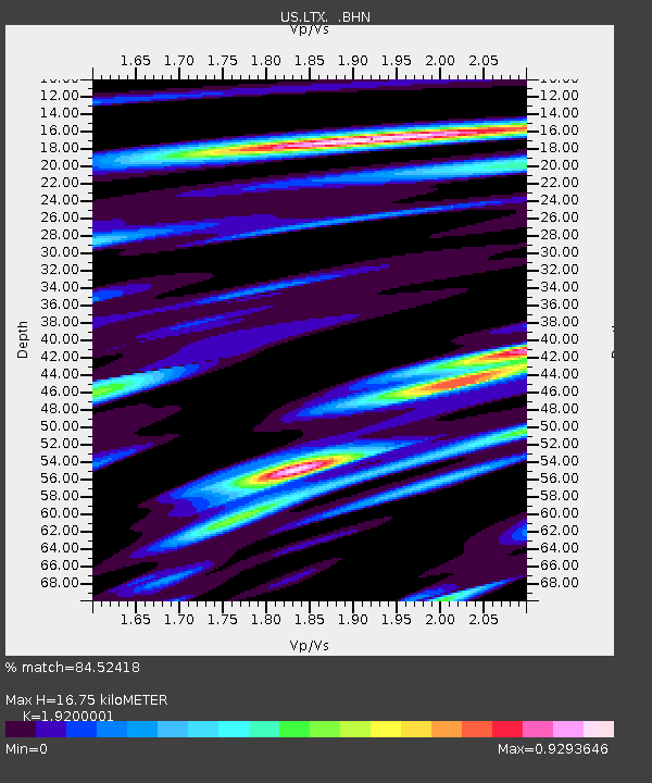
| Estimated Moho Depth: |
16.75 km |
| Estimated Crust Vp/Vs: |
1.92 |
| Assumed Crust Vp: |
6.419 km/s |
| Estimated Crust Vs: |
3.343 km/s |
| Estimated Crust Poisson's Ratio: |
0.31 |
|
| Radial Match: |
84.52418 % |
| Radial Bump: |
400 |
| Transverse Match: |
72.33721 % |
| Transverse Bump: |
400 |
| SOD ConfigId: |
2669 |
| Insert Time: |
2010-03-05 07:02:26.501 +0000 |
| GWidth: |
2.5 |
| Max Bumps: |
400 |
| Tol: |
0.001 |
|
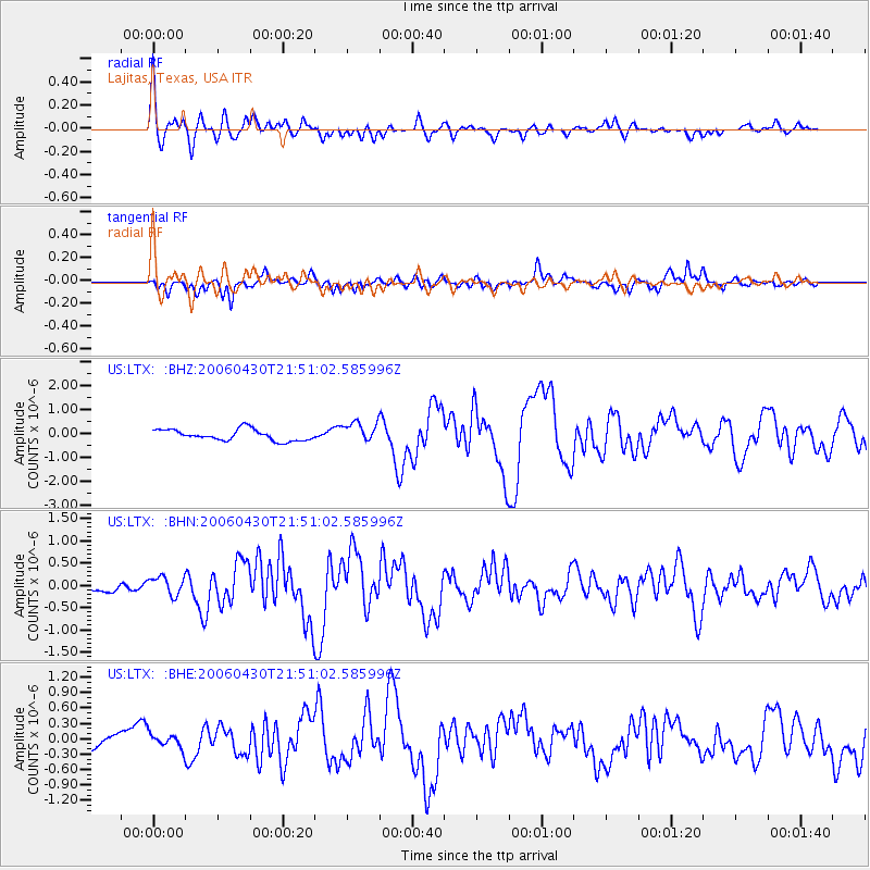
Signal To Noise
| Channel | StoN | STA | LTA |
| US:LTX: :BHN:20060430T21:51:02.585996Z | 2.3767948 | 2.1171499E-7 | 8.907583E-8 |
| US:LTX: :BHE:20060430T21:51:02.585996Z | 0.95984375 | 1.3690547E-7 | 1.4263308E-7 |
| US:LTX: :BHZ:20060430T21:51:02.585996Z | 1.8393162 | 4.2423682E-7 | 2.306492E-7 |
| Arrivals |
| Ps | 2.5 SECOND |
| PpPs | 7.3 SECOND |
| PsPs/PpSs | 9.8 SECOND |


