You are here: Home > Network List > US - United States National Seismic Network Stations List
> Station LTX Lajitas, Texas, USA > Earthquake Result Viewer
LTX Lajitas, Texas, USA - Earthquake Result Viewer
| Earthquake location: |
Eastern Siberia, Russia |
| Earthquake latitude/longitude: |
60.5/165.8 |
| Earthquake time(UTC): |
2006/04/21 (111) 04:32:43 GMT |
| Earthquake Depth: |
9.0 km |
| Earthquake Magnitude: |
6.3 MB, 5.6 MS, 6.1 MW, 6.1 ME |
| Earthquake Catalog/Contributor: |
WHDF/NEIC |
|
| Network: |
US United States National Seismic Network |
| Station: |
LTX Lajitas, Texas, USA |
| Lat/Lon: |
29.33 N/103.67 W |
| Elevation: |
1013 m |
|
| Distance: |
65.2 deg |
| Az: |
74.151 deg |
| Baz: |
326.988 deg |
| Ray Param: |
0.05844202 |
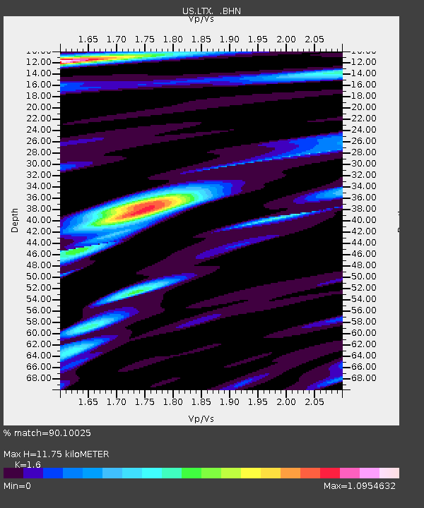
| Estimated Moho Depth: |
11.75 km |
| Estimated Crust Vp/Vs: |
1.60 |
| Assumed Crust Vp: |
6.419 km/s |
| Estimated Crust Vs: |
4.012 km/s |
| Estimated Crust Poisson's Ratio: |
0.18 |
|
| Radial Match: |
90.10025 % |
| Radial Bump: |
400 |
| Transverse Match: |
77.67656 % |
| Transverse Bump: |
400 |
| SOD ConfigId: |
2669 |
| Insert Time: |
2010-03-05 07:02:33.164 +0000 |
| GWidth: |
2.5 |
| Max Bumps: |
400 |
| Tol: |
0.001 |
|
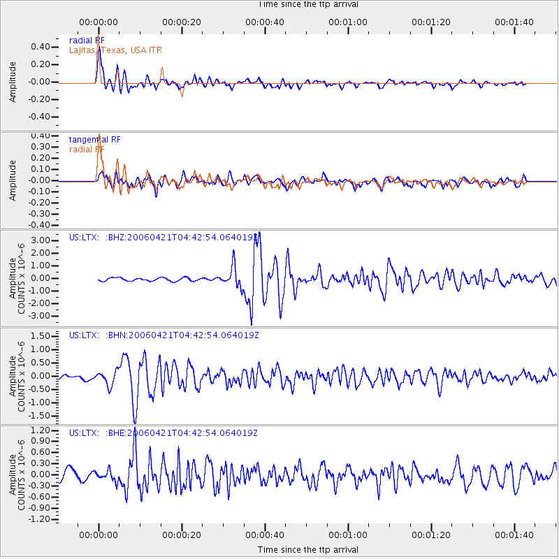
Signal To Noise
| Channel | StoN | STA | LTA |
| US:LTX: :BHN:20060421T04:42:54.064019Z | 3.7304218 | 2.7270764E-7 | 7.31037E-8 |
| US:LTX: :BHE:20060421T04:42:54.064019Z | 1.0269858 | 1.3534442E-7 | 1.3178803E-7 |
| US:LTX: :BHZ:20060421T04:42:54.064019Z | 6.411343 | 8.208041E-7 | 1.2802374E-7 |
| Arrivals |
| Ps | 1.2 SECOND |
| PpPs | 4.5 SECOND |
| PsPs/PpSs | 5.7 SECOND |


