You are here: Home > Network List > US - United States National Seismic Network Stations List
> Station LTX Lajitas, Texas, USA > Earthquake Result Viewer
LTX Lajitas, Texas, USA - Earthquake Result Viewer

| Earthquake location: |
Fox Islands, Aleutian Islands |
| Earthquake latitude/longitude: |
52.6/-167.8 |
| Earthquake time(UTC): |
2000/12/05 (340) 22:11:34 GMT |
| Earthquake Depth: |
33 km |
| Earthquake Magnitude: |
5.6 MB, 5.6 MS, 5.9 MW, 5.4 ML |
| Earthquake Catalog/Contributor: |
WHDF/NEIC |
|
| Network: |
US United States National Seismic Network |
| Station: |
LTX Lajitas, Texas, USA |
| Lat/Lon: |
29.33 N/103.67 W |
| Elevation: |
1013 m |
|
| Distance: |
51.8 deg |
| Az: |
90.279 deg |
| Baz: |
315.662 deg |
| Ray Param: |
0.06710262 |
| Estimated Moho Depth: |
37.5 km |
| Estimated Crust Vp/Vs: |
1.73 |
| Assumed Crust Vp: |
6.419 km/s |
| Estimated Crust Vs: |
3.716 km/s |
| Estimated Crust Poisson's Ratio: |
0.25 |
|
| Radial Match: |
81.273026 % |
| Radial Bump: |
400 |
| Transverse Match: |
75.399376 % |
| Transverse Bump: |
400 |
| SOD ConfigId: |
110165 |
| Insert Time: |
2010-03-05 07:02:44.774 +0000 |
| GWidth: |
2.5 |
| Max Bumps: |
400 |
| Tol: |
0.001 |
|
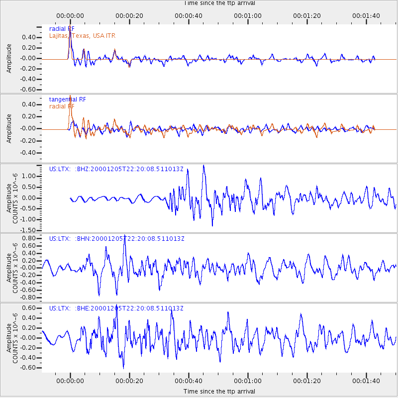
Signal To Noise
| Channel | StoN | STA | LTA |
| US:LTX: :BHN:20001205T22:20:08.511013Z | 0.6188589 | 6.427393E-8 | 1.0385878E-7 |
| US:LTX: :BHE:20001205T22:20:08.511013Z | 1.543968 | 1.4930934E-7 | 9.670496E-8 |
| US:LTX: :BHZ:20001205T22:20:08.511013Z | 2.3807595 | 2.1012528E-7 | 8.825977E-8 |
| Arrivals |
| Ps | 4.5 SECOND |
| PpPs | 15 SECOND |
| PsPs/PpSs | 20 SECOND |


