You are here: Home > Network List > TJ - Tajikistan National Seismic Network Stations List
> Station GARM Garm, Tajikistan > Earthquake Result Viewer
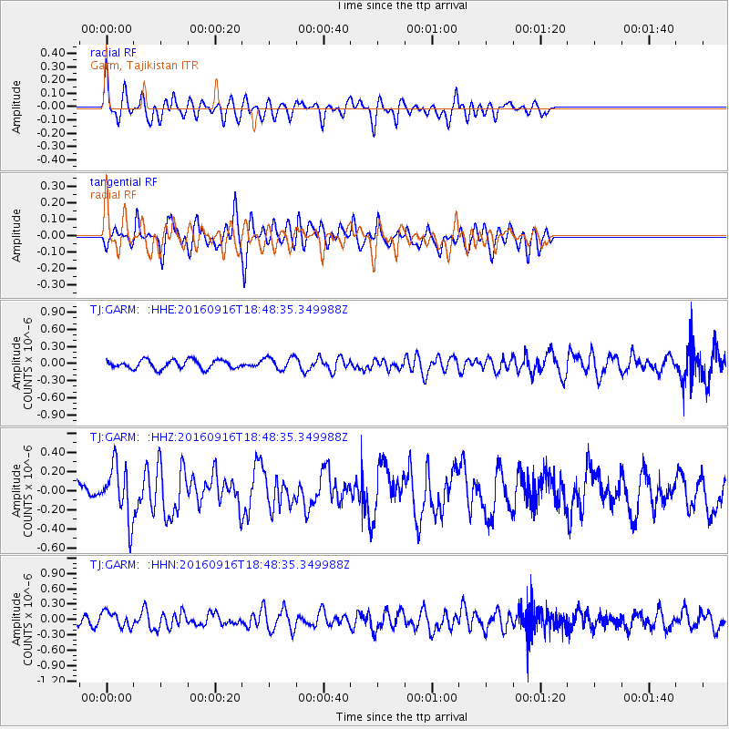
GARM Garm, Tajikistan - Earthquake Result Viewer
*The percent match for this event was below the threshold and hence no stack was calculated.
| Earthquake location: |
Southwest Indian Ridge |
| Earthquake latitude/longitude: |
-29.1/60.9 |
| Earthquake time(UTC): |
2016/09/16 (260) 18:38:05 GMT |
| Earthquake Depth: |
10 km |
| Earthquake Magnitude: |
5.5 MB, 5.4 MWB, 5.5 MWC |
| Earthquake Catalog/Contributor: |
NEIC PDE/NEIC COMCAT |
|
| Network: |
TJ Tajikistan National Seismic Network |
| Station: |
GARM Garm, Tajikistan |
| Lat/Lon: |
39.00 N/70.32 E |
| Elevation: |
1305 m |
|
| Distance: |
68.4 deg |
| Az: |
7.855 deg |
| Baz: |
188.826 deg |
| Ray Param: |
$rayparam |
*The percent match for this event was below the threshold and hence was not used in the summary stack. |
|
| Radial Match: |
56.27917 % |
| Radial Bump: |
400 |
| Transverse Match: |
55.31402 % |
| Transverse Bump: |
400 |
| SOD ConfigId: |
11737051 |
| Insert Time: |
2019-04-25 13:15:28.479 +0000 |
| GWidth: |
2.5 |
| Max Bumps: |
400 |
| Tol: |
0.001 |
|
Signal To Noise
| Channel | StoN | STA | LTA |
| TJ:GARM: :HHZ:20160916T18:48:35.349988Z | 3.399294 | 2.857675E-7 | 8.406672E-8 |
| TJ:GARM: :HHN:20160916T18:48:35.349988Z | 2.5809305 | 1.5470067E-7 | 5.9939886E-8 |
| TJ:GARM: :HHE:20160916T18:48:35.349988Z | 1.5143334 | 1.1563255E-7 | 7.635872E-8 |
| Arrivals |
| Ps | |
| PpPs | |
| PsPs/PpSs | |


