You are here: Home > Network List > US - United States National Seismic Network Stations List
> Station LTX Lajitas, Texas, USA > Earthquake Result Viewer
LTX Lajitas, Texas, USA - Earthquake Result Viewer
| Earthquake location: |
Vanuatu Islands |
| Earthquake latitude/longitude: |
-15.4/166.9 |
| Earthquake time(UTC): |
2000/10/04 (278) 16:58:44 GMT |
| Earthquake Depth: |
23 km |
| Earthquake Magnitude: |
6.1 MB, 6.9 MS, 6.8 MW, 6.5 ME |
| Earthquake Catalog/Contributor: |
WHDF/NEIC |
|
| Network: |
US United States National Seismic Network |
| Station: |
LTX Lajitas, Texas, USA |
| Lat/Lon: |
29.33 N/103.67 W |
| Elevation: |
1013 m |
|
| Distance: |
96.9 deg |
| Az: |
61.585 deg |
| Baz: |
256.279 deg |
| Ray Param: |
0.040364552 |
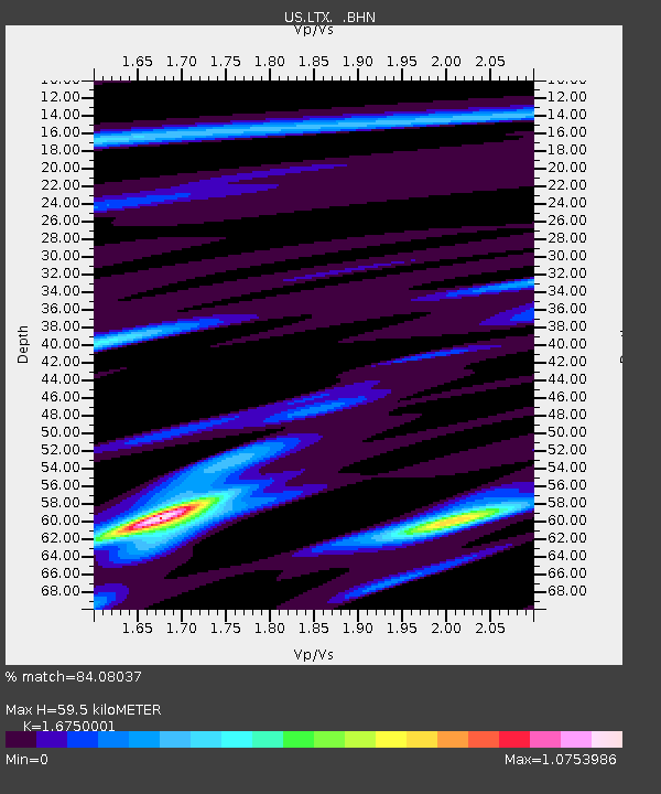
| Estimated Moho Depth: |
59.5 km |
| Estimated Crust Vp/Vs: |
1.68 |
| Assumed Crust Vp: |
6.419 km/s |
| Estimated Crust Vs: |
3.832 km/s |
| Estimated Crust Poisson's Ratio: |
0.22 |
|
| Radial Match: |
84.08037 % |
| Radial Bump: |
369 |
| Transverse Match: |
72.43199 % |
| Transverse Bump: |
400 |
| SOD ConfigId: |
110165 |
| Insert Time: |
2010-03-05 07:02:46.953 +0000 |
| GWidth: |
2.5 |
| Max Bumps: |
400 |
| Tol: |
0.001 |
|
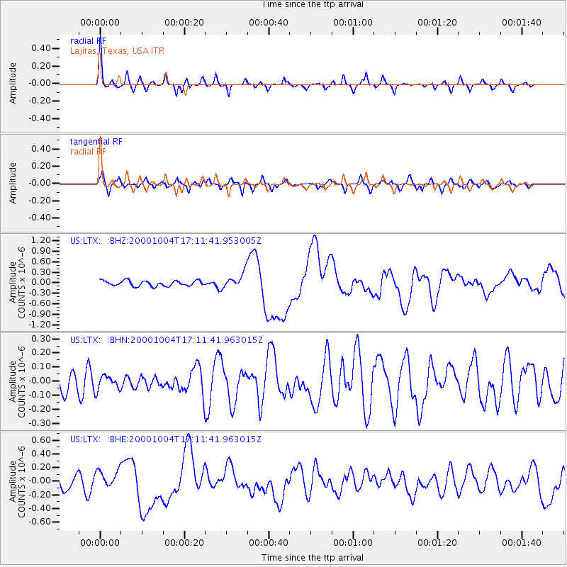
Signal To Noise
| Channel | StoN | STA | LTA |
| US:LTX: :BHN:20001004T17:11:41.963015Z | 0.47528058 | 4.774669E-8 | 1.0046001E-7 |
| US:LTX: :BHE:20001004T17:11:41.963015Z | 1.0464286 | 1.3533308E-7 | 1.2932854E-7 |
| US:LTX: :BHZ:20001004T17:11:41.953005Z | 3.0063148 | 2.2584015E-7 | 7.5121925E-8 |
| Arrivals |
| Ps | 6.4 SECOND |
| PpPs | 24 SECOND |
| PsPs/PpSs | 31 SECOND |


