You are here: Home > Network List > US - United States National Seismic Network Stations List
> Station LTX Lajitas, Texas, USA > Earthquake Result Viewer
LTX Lajitas, Texas, USA - Earthquake Result Viewer
| Earthquake location: |
Sakhalin, Russia |
| Earthquake latitude/longitude: |
48.8/142.2 |
| Earthquake time(UTC): |
2000/08/04 (217) 21:13:02 GMT |
| Earthquake Depth: |
10 km |
| Earthquake Magnitude: |
6.3 MB, 7.1 MS, 6.8 MW, 6.7 MW |
| Earthquake Catalog/Contributor: |
WHDF/NEIC |
|
| Network: |
US United States National Seismic Network |
| Station: |
LTX Lajitas, Texas, USA |
| Lat/Lon: |
29.33 N/103.67 W |
| Elevation: |
1013 m |
|
| Distance: |
82.5 deg |
| Az: |
53.51 deg |
| Baz: |
322.487 deg |
| Ray Param: |
0.04681862 |
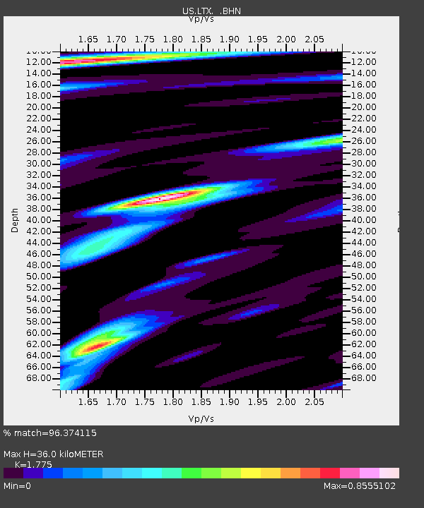
| Estimated Moho Depth: |
36.0 km |
| Estimated Crust Vp/Vs: |
1.77 |
| Assumed Crust Vp: |
6.419 km/s |
| Estimated Crust Vs: |
3.616 km/s |
| Estimated Crust Poisson's Ratio: |
0.27 |
|
| Radial Match: |
96.374115 % |
| Radial Bump: |
400 |
| Transverse Match: |
91.96039 % |
| Transverse Bump: |
400 |
| SOD ConfigId: |
110165 |
| Insert Time: |
2010-03-05 07:02:58.095 +0000 |
| GWidth: |
2.5 |
| Max Bumps: |
400 |
| Tol: |
0.001 |
|
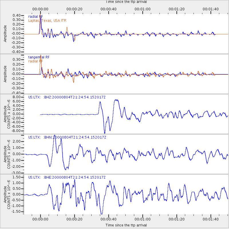
Signal To Noise
| Channel | StoN | STA | LTA |
| US:LTX: :BHN:20000804T21:24:54.152017Z | 5.2533493 | 2.8678767E-7 | 5.4591396E-8 |
| US:LTX: :BHE:20000804T21:24:54.152017Z | 4.7542577 | 1.9397487E-7 | 4.080024E-8 |
| US:LTX: :BHZ:20000804T21:24:54.152017Z | 19.087713 | 1.3990622E-6 | 7.3296476E-8 |
| Arrivals |
| Ps | 4.5 SECOND |
| PpPs | 15 SECOND |
| PsPs/PpSs | 20 SECOND |


